Nearly hidden off the side of a busy four-lane street in Cary, NC, near aesthetically pleasing shopping center strips and fast-food restaurants is a 140-acre sanctuary for plants, trees, and humans who need a break from the city.
Located southwest of Raleigh, just east of Hwy 1, Hemlock Bluffs Nature Preserve provides visitors with a relaxing walk through the woods. Trails totaling approximately 3.6 miles wind through a forest of beech, pine, and chestnut oaks; around one of the Piedmont's rare bluffs, and down into the bottom lands along Swift Creek. Topographical features that provide the idea settling for the park's main attraction--mountain loving hemlock trees.
As the old saying goes, moss only grows on the north side of trees, for the northern face is cool and shady, and often, the sun's rays never strike that side of an object as the sun tracks from east to west. That, along with the steep bluff, is why hemlocks and other mountain plants such as galax and trillium grow this far over in the Piedmont.
During our visit, we hiked the wide, mulch-covered Chestnut Oak Loop Trail on the western side of the bluff that overlooks Swift Creek. Along the way, we spotted an overlook and benches, and passed the turnoffs for the Beech Tree Cove and West Hemlock Overlook Trails. Next, we strolled along the path to the eastern side of the bluff, and after relaxing at the overlook, we took the steps down the hill to the Swift Creek Trail. A boardwalk runs along Swift Creek and loops through quiet woods and what are usually wetlands, but were dry on this occasion.
The sound of traffic could be heard throughout most of the hike, but it wasn't distracting. Nor did it drown out the chirps and songs of birds flitting in the trees. A variety of wildlife calls the preserve home, including snakes. One of which we spotted in a far-off puddle. As always, when walking through the great outdoors, be careful.
The Hemlock Bluff Nature Preserve also offers a nature center and a wildflower garden. A great stop for those living in or near, or visiting the Triangle area.

A personal glimpse of outdoor destinations in and around the Carolinas. All photos and content copyrighted.
Showing posts with label Piedmont. Show all posts
Showing posts with label Piedmont. Show all posts
Morrow Mountain State Park
Like Landsford Canal State Park in SC and the NC Zoo, Morrow Mountain is one of those "far" places we put off visiting until we could spend the night in the area. But last week, I was craving a mountain hike, so we packed up and took a long drive.
Morrow Mountain is nestled in a curve along the western edge of the Uhwarrie Forest, separated from the forest by the Yadkin/Pee Dee Rivers. It's in the Piedmont where mountains shouldn't exist. But North Carolina has several "little mountains" as the host of Exploring North Carolina called them. Mountains outside of the mountain range. This is due to the fact that NC is made up of strips of land called terranes. In short, the foothills of the Blue Ridge was once the original edge of North America, but additional land masses collided into that edge, forming the Old North State, as seen here in this USGS image:
http://tapestry.usgs.gov/states/northcarolina.html
When things collide, one or both sides buckle, creating folds. Water eroded much of the land in these folds, but erosion-resistant rock remained in some places, leaving behind peaks such as Pilot, Medoc, and Morrow Mountain. Consequently, elevated views exist in the Piedmont.

That erosion-resistant rock is the second reason Morrow Mountain is special. It has (rather, it is) an abundance of rock, including ryolite, rock with grains so small, they're undetectable to the eye.

 Natives such as the Pee Dee tribe hauled the resilient rock down the mountain to other locations where they converted the stone into arrowheads or tools. Evidence of that activity still exist throughout the park. In addition to the presence of an ancient quarry, chips and shards litter the mountain side, including the Mountain Loop Trail near a summit that offers a breathtaking view of Lake Tillery.
Morrow Mountain has fourteen trails, three of which are bridle, though hiking is permitted on each at the time of this writing. The trails range from .6 to 9 miles, and from easy to strenuous. A boat ramp is available for those who would like to boat along the Yadkin. Rowboats and canoes are available for rental, as are cabins. Check the park's website for fees and availability.
As we quickly learned, Morrow Mountain is worth the drive. For more information, go to www.ncparks.gov/Visit/parks/momo/main.php
Morrow Mountain is nestled in a curve along the western edge of the Uhwarrie Forest, separated from the forest by the Yadkin/Pee Dee Rivers. It's in the Piedmont where mountains shouldn't exist. But North Carolina has several "little mountains" as the host of Exploring North Carolina called them. Mountains outside of the mountain range. This is due to the fact that NC is made up of strips of land called terranes. In short, the foothills of the Blue Ridge was once the original edge of North America, but additional land masses collided into that edge, forming the Old North State, as seen here in this USGS image:
http://tapestry.usgs.gov/states/northcarolina.html
When things collide, one or both sides buckle, creating folds. Water eroded much of the land in these folds, but erosion-resistant rock remained in some places, leaving behind peaks such as Pilot, Medoc, and Morrow Mountain. Consequently, elevated views exist in the Piedmont.


Morrow Mountain has fourteen trails, three of which are bridle, though hiking is permitted on each at the time of this writing. The trails range from .6 to 9 miles, and from easy to strenuous. A boat ramp is available for those who would like to boat along the Yadkin. Rowboats and canoes are available for rental, as are cabins. Check the park's website for fees and availability.
As we quickly learned, Morrow Mountain is worth the drive. For more information, go to www.ncparks.gov/Visit/parks/momo/main.php
De Hart Botanical Gardens, Franklin Co, NC
Sunny with a high in the mid 80s. After a long winter, we couldn't waste a day like that indoors, so we slipped on our hiking shoes and headed outside.
But where to go?
Before we left, I'd grabbed my copy of 100 Classic Hikes in North Carolina, which I'd purchased last year and had yet to use. As my husband drove to Bojangles for my beloved iced tea, I flipped to the index and read each entry under the Coast Trails, Piedmont, and More Piedmont Trails headings. One caught my eye, and after reading the description, we were on our way to the Franklin County Nature Preserve of the De Hart Botanical Gardens.
 Located on Hwy 401, about 4.7 miles north of Hwy 98 in Franklin County, the eighty-eight acre preserve is home to a rare flower and crane-fly orchids, thanks to its unique location along NC's Fall zone. Signs at the trailhead state the land is private, but open to the public provided they follow the rules. The first is to sign in at a picturesque gazebo. A gracious deal no matter how you look at it, so after signing in, we collected a map from the brochure box and headed down the first of many trails.
The park is separated into two sections. Each section has 1.8 miles of hiking trails and different, but really cool features. We started out at Section B: the Waterfall Loop.
Yes, a waterfall! After hiking over a bridge and past boulders and rock outcroppings (more on that in a minute), we made our way around a switchback and faced a small waterfall. It may have been far shorter than Looking Glass or Schoolhouse Falls, but it was still a waterfall, and it's located in eastern NC.

 We continued on, taking a short sidetrail to see—according to 100 Hikes—the remnants of the old Timberlake homestead. I have no information on the family, though I'd love to know more about them. Beyond some scrap metal and a large hole in the ground, we saw only the peaceful outdoors, the beginnings of a large spread of daffodils, and two of the biggest trees we've seen outside of Congaree Swamp in South Carolina. Definitely worth the short detour, especially when the daffodils are in bloom (which they were not during our visit).

What a colorful touch to add to a farm then so far from civilization. And what a wonderful gift left behind for the rest of us.
After touring the grounds, we picked up the original trail, at times following a creek, once passing a pond, until we looped back to the the trailhead. From there, we crossed the parking lot to Section A.
The loop trail in this section consists of several trails. The first, the Rock Trail. As I mentioned, the botanical gardens is located on the Fall Zone and, as at Rocky Mount and Raven Rock State Park, large boulders left behind from erosion are visible throughout the preserve, which increases the challenge of the hikes at times.


Since my geological knowledge is limited to several chapters of Geology of the Carolinas, I cannot begin to explain the slab of land apparently known as the Carolina terrane, which makes up a portion of the eastern section of the Piedmont. If you gotta-have-to-need-to-know, read Chapter 24 of Geology of the Carolinas.
Near the end of the Rock Trail, we reached a small observation deck overlooking a scenic lake. This is a great place to stop, rest, and take pictures.


After doing all of the above, we continued on and found a marker for the wildpink, a flower that, according to several sources, grows only along the granite-rich area of the Fall Zone. Since spring was just awakening at the time of our visit, the little darling was still catching up on her beauty sleep. We're planning to return in April in the hopes of catching it in bloom.
 But we had more to see, so we strolled along the banks of the lake and crossed the bridge, and there we found the Crane Fly Trail. According to James Fowler's Wild Orchids of South Carolina, the Crane fly blooms from mid-July to mid-August. We spotted one once, in Pisgah National Forest, located in western NC, and had no idea they grew on this side of the state. They do. We found the leaves and seed pods. What a delight it will be to see them at peak.
According to 100 Hikes, in addition to Crane-fly orchids and wildpinks, the preserve is home to a variety of trees, azaleas, and mint. Mint? Not much was blooming during our March visit though, but we did spot some bluets, violets, and phlox.

All this hidden in what others would call the middle of nowhere. The Carolinas do love their secrets.
During this particular hike, I had a chest cold. Roughly three miles of hiking was all I could take, so we missed exploring the Bench Loop and the Children's Bamboo Loop. Next time.
On another note, don't forget to take precautions against ticks when walking in the woods in eastern NC. Though just mid-March, one hitched a ride home with us.
Our thanks to the owners of the De Hart Botanical Gardens for graciously opening the grounds to the public, and allowing us to enjoy the wonders there.
But where to go?
Before we left, I'd grabbed my copy of 100 Classic Hikes in North Carolina, which I'd purchased last year and had yet to use. As my husband drove to Bojangles for my beloved iced tea, I flipped to the index and read each entry under the Coast Trails, Piedmont, and More Piedmont Trails headings. One caught my eye, and after reading the description, we were on our way to the Franklin County Nature Preserve of the De Hart Botanical Gardens.
 Located on Hwy 401, about 4.7 miles north of Hwy 98 in Franklin County, the eighty-eight acre preserve is home to a rare flower and crane-fly orchids, thanks to its unique location along NC's Fall zone. Signs at the trailhead state the land is private, but open to the public provided they follow the rules. The first is to sign in at a picturesque gazebo. A gracious deal no matter how you look at it, so after signing in, we collected a map from the brochure box and headed down the first of many trails.
The park is separated into two sections. Each section has 1.8 miles of hiking trails and different, but really cool features. We started out at Section B: the Waterfall Loop.
Yes, a waterfall! After hiking over a bridge and past boulders and rock outcroppings (more on that in a minute), we made our way around a switchback and faced a small waterfall. It may have been far shorter than Looking Glass or Schoolhouse Falls, but it was still a waterfall, and it's located in eastern NC.

 We continued on, taking a short sidetrail to see—according to 100 Hikes—the remnants of the old Timberlake homestead. I have no information on the family, though I'd love to know more about them. Beyond some scrap metal and a large hole in the ground, we saw only the peaceful outdoors, the beginnings of a large spread of daffodils, and two of the biggest trees we've seen outside of Congaree Swamp in South Carolina. Definitely worth the short detour, especially when the daffodils are in bloom (which they were not during our visit).
What a colorful touch to add to a farm then so far from civilization. And what a wonderful gift left behind for the rest of us.
After touring the grounds, we picked up the original trail, at times following a creek, once passing a pond, until we looped back to the the trailhead. From there, we crossed the parking lot to Section A.
The loop trail in this section consists of several trails. The first, the Rock Trail. As I mentioned, the botanical gardens is located on the Fall Zone and, as at Rocky Mount and Raven Rock State Park, large boulders left behind from erosion are visible throughout the preserve, which increases the challenge of the hikes at times.


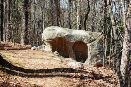
Since my geological knowledge is limited to several chapters of Geology of the Carolinas, I cannot begin to explain the slab of land apparently known as the Carolina terrane, which makes up a portion of the eastern section of the Piedmont. If you gotta-have-to-need-to-know, read Chapter 24 of Geology of the Carolinas.
Near the end of the Rock Trail, we reached a small observation deck overlooking a scenic lake. This is a great place to stop, rest, and take pictures.


Honey, you didn't tell me we were having company!
After doing all of the above, we continued on and found a marker for the wildpink, a flower that, according to several sources, grows only along the granite-rich area of the Fall Zone. Since spring was just awakening at the time of our visit, the little darling was still catching up on her beauty sleep. We're planning to return in April in the hopes of catching it in bloom.

According to 100 Hikes, in addition to Crane-fly orchids and wildpinks, the preserve is home to a variety of trees, azaleas, and mint. Mint? Not much was blooming during our March visit though, but we did spot some bluets, violets, and phlox.

All this hidden in what others would call the middle of nowhere. The Carolinas do love their secrets.
During this particular hike, I had a chest cold. Roughly three miles of hiking was all I could take, so we missed exploring the Bench Loop and the Children's Bamboo Loop. Next time.
On another note, don't forget to take precautions against ticks when walking in the woods in eastern NC. Though just mid-March, one hitched a ride home with us.
Our thanks to the owners of the De Hart Botanical Gardens for graciously opening the grounds to the public, and allowing us to enjoy the wonders there.
Peachtree Rock Heritage Preserve, South Carolina
During a recent trip to Columbia, SC, we found ourselves with enough time to explore Peachtree Rock Heritage Preserve, a Nature Conservancy (SC Chapter) project just over thirty miles outside the city. As I mentioned in a previous post, if a conservancy acquires a tract of land, there's a good reason for it, so they're worth checking out.
The prized object of this conservancy is something that borders on comical, begging the question, How did it happen? But as we discovered, there's more to see at Peachtree.
 Following the directions listed on two websites, we found the preserve without any difficulty. After parking in the small, dirt lot located at the trailhead, we grabbed our camera and headed down the sandy trail.


We walked through the woods, avoiding the usual trail hazards such as roots and rocks in the ground. About a quarter mile into the trail (purely guessing here), we reached a T-Junction. To our right, the trail extended past a sandstone ledge hanging several feet above the path. According to the South Carolina Department of Natural Resources, Peachtree Preserve has the largest sandstone outcroppings in the state.1
We turned left, and a couple tenths of a mile later, we reached our goal. While we stared at the curious formation, a sound caught our attention, and we followed the trail to the end and found something we hadn't known to look for.

A waterfall. The only one in the coastal plains. As I understand it, at the time of this writing, the state is experiencing drought conditions, so I don't know if the thin stream of water we saw flowing over the ten-ish foot ledge is normal, but it made the landscape even more scenic. We walked to the falls on dry ground, and stood close enough to feel the mist spraying off the rocks.

A pleasant surprise.
Okay, by now you must be wondering about the curious formation that brought us to Peachtree Rock Preserve, and why I've yet to show a photo. Here's why.

That's right. It's a giant inverted triangular rock. With a tree perched on top.

Lest anyone get the wrong impression, I think it's great. It's an incredibly unique, peculiar formation. One that should be viewed in person to appreciate the size and mass resting on that rounded point.
I was curious both about the shape and why the sandy landscape had rock ledges in the first place. According to the Conservancy's website, the softer, sandier material at the bottom of the rock eroded faster than the sandstone above it. I assume the entire area is a result of erosion. Take a closer look at the rock near the waterfall:

But interesting rock formations and a pleasant little waterfall aren't the only attractions at the preserve. As I later learned, according to the Nature Conservancy's website, we missed several natural communities:

I'm sorely behind on the subject of longleaf pines, but intend to cover it in an upcoming post.
Peachtree Rock Heritage Preserve is located near Edmund, SC.
The prized object of this conservancy is something that borders on comical, begging the question, How did it happen? But as we discovered, there's more to see at Peachtree.


We walked through the woods, avoiding the usual trail hazards such as roots and rocks in the ground. About a quarter mile into the trail (purely guessing here), we reached a T-Junction. To our right, the trail extended past a sandstone ledge hanging several feet above the path. According to the South Carolina Department of Natural Resources, Peachtree Preserve has the largest sandstone outcroppings in the state.1
We turned left, and a couple tenths of a mile later, we reached our goal. While we stared at the curious formation, a sound caught our attention, and we followed the trail to the end and found something we hadn't known to look for.

A waterfall. The only one in the coastal plains. As I understand it, at the time of this writing, the state is experiencing drought conditions, so I don't know if the thin stream of water we saw flowing over the ten-ish foot ledge is normal, but it made the landscape even more scenic. We walked to the falls on dry ground, and stood close enough to feel the mist spraying off the rocks.

A pleasant surprise.
Okay, by now you must be wondering about the curious formation that brought us to Peachtree Rock Preserve, and why I've yet to show a photo. Here's why.

That's right. It's a giant inverted triangular rock. With a tree perched on top.

Lest anyone get the wrong impression, I think it's great. It's an incredibly unique, peculiar formation. One that should be viewed in person to appreciate the size and mass resting on that rounded point.
I was curious both about the shape and why the sandy landscape had rock ledges in the first place. According to the Conservancy's website, the softer, sandier material at the bottom of the rock eroded faster than the sandstone above it. I assume the entire area is a result of erosion. Take a closer look at the rock near the waterfall:

But interesting rock formations and a pleasant little waterfall aren't the only attractions at the preserve. As I later learned, according to the Nature Conservancy's website, we missed several natural communities:
The area harbors a swamp tupelo-evergreen shrub bog and a longleaf pine ecosystem. Typical sandhill scrub vegetation, pines, turkey oaks and sparkleberry bushes are present in abundance on the preserve. The federally endangered Rayner's blueberry is found growing on the seepage slope within the longleaf pine forest.2

I'm sorely behind on the subject of longleaf pines, but intend to cover it in an upcoming post.
Peachtree Rock Heritage Preserve is located near Edmund, SC.
Scouting Out Uwharrie
We recently took a scouting trip to Uwharrie National Forest to learn the layout and enjoy a beautiful autumn day.
Named for the Uwharrie Mountains and acquired by the government during the Great Depression, Uwharrie is one of four national forests in North Carolina. It's situated in the Piedmont, south of Asheboro and west of the North Carolina Zoo. Tucked in a curve on the forest's western boundary is Morrow Mountain State Park.
Our GPS led us to a completely useless spot just inside the eastern edge of the forest, near what appeared to be a charming town named Troy. After consulting the Gazetteer, we headed north on 109, but stopped at a parking lot several miles up the road. This turned out to be one of three trailheads for the 20.5 Uwharrie Trail, which cuts a swath across the forest.
 We didn't have the time or the stamina to hike the entire trail on this day, nor did we have a map, available at the ranger station down the road, according to the kiosk at the trailhead. We did, however, take an hour-long trek over a dirt path embedded with rocks, roots and even quartz in what turned out to be a pleasant walk in the woods. Sunlight streamed through autumn-tinted leaves, some on trees, some littering the ground, and we strolled to a creek where we found several Hearts-a-Burstings.

Caught! Your host:

Trail near the creek:

Strawberry bush known as Hearts-a-Bursting:

On the subject of flowers, we spotted the following species of sunflower growing alongside the road. Did we find the endangered Schweitzer's Sunflower, known to grow in the Uwharrie Forest, or one of its cousins?


We finished our hike, but instead of backtracking through Troy, we headed north on 109 to NC 49, one of North Carolina's official scenic drives, and soon found more destinations to explore.
Last year, one of my Sylvan Heights posts caught the attention of the NC Zoo director. He not only invited us to the zoo, he suggested we check out Birkhead Wilderness, located in the northern region of the Uwharrie National Forest. Our zoo trip is a bit overdue thanks to unexpected travel and 100+ temperatures this past summer, but on this trip, we spotted the turnoff for the 5,100 acre Birkhead Wilderness. So many trails, too little time! We put it on the growing lists of places to visit, and continued on, but made a quick turn when we saw the sign for Pisgah Covered Bridge.
A member of our hiking group first told us about this historic structure. Several sources state the Pisgah Covered Bridge is only one of two covered bridges left in North Carolina. Once badly damaged, the bridge was refurbished thanks to efforts initiated by the NC Zoo and Zoo Society. Today, visitors can picnic near the creek or stroll along the hiking trail in what we found to be a picturesque setting.


A must see if you're in the area.
There are several trails to explore in Uwharrie National Forest, Birkhead Wilderness, and nearby Morrow Mountain State Park, and that's not even counting the hike through the NC Zoo. In short, there's plenty to do in the Asheboro area.
And I once called the Piedmont the land between me and the mountains? I stand corrected.
So back we'll go, and soon. Not to explore more of Uwharrie's interior, not yet anyway. We're finally taking that overdue trip to the zoo. But we won't be alone. Accompanying us on the excursion will be a group of siblings who have fast grown dear to our hearts. More soon.
For more information on Uwharrie Forest, activities and trails, go to www.cs.unca.edu/nfsnc/recreation/uwharrie/index.htm
For more information on Morrow Mountain State Park, go to
www.ncparks.gov/Visit/parks/momo/main.php
Named for the Uwharrie Mountains and acquired by the government during the Great Depression, Uwharrie is one of four national forests in North Carolina. It's situated in the Piedmont, south of Asheboro and west of the North Carolina Zoo. Tucked in a curve on the forest's western boundary is Morrow Mountain State Park.
Our GPS led us to a completely useless spot just inside the eastern edge of the forest, near what appeared to be a charming town named Troy. After consulting the Gazetteer, we headed north on 109, but stopped at a parking lot several miles up the road. This turned out to be one of three trailheads for the 20.5 Uwharrie Trail, which cuts a swath across the forest.


Caught! Your host:

Trail near the creek:

Strawberry bush known as Hearts-a-Bursting:

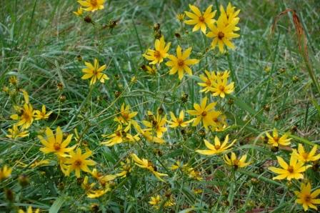
On the subject of flowers, we spotted the following species of sunflower growing alongside the road. Did we find the endangered Schweitzer's Sunflower, known to grow in the Uwharrie Forest, or one of its cousins?

We finished our hike, but instead of backtracking through Troy, we headed north on 109 to NC 49, one of North Carolina's official scenic drives, and soon found more destinations to explore.
Last year, one of my Sylvan Heights posts caught the attention of the NC Zoo director. He not only invited us to the zoo, he suggested we check out Birkhead Wilderness, located in the northern region of the Uwharrie National Forest. Our zoo trip is a bit overdue thanks to unexpected travel and 100+ temperatures this past summer, but on this trip, we spotted the turnoff for the 5,100 acre Birkhead Wilderness. So many trails, too little time! We put it on the growing lists of places to visit, and continued on, but made a quick turn when we saw the sign for Pisgah Covered Bridge.
A member of our hiking group first told us about this historic structure. Several sources state the Pisgah Covered Bridge is only one of two covered bridges left in North Carolina. Once badly damaged, the bridge was refurbished thanks to efforts initiated by the NC Zoo and Zoo Society. Today, visitors can picnic near the creek or stroll along the hiking trail in what we found to be a picturesque setting.


A must see if you're in the area.
There are several trails to explore in Uwharrie National Forest, Birkhead Wilderness, and nearby Morrow Mountain State Park, and that's not even counting the hike through the NC Zoo. In short, there's plenty to do in the Asheboro area.
And I once called the Piedmont the land between me and the mountains? I stand corrected.
So back we'll go, and soon. Not to explore more of Uwharrie's interior, not yet anyway. We're finally taking that overdue trip to the zoo. But we won't be alone. Accompanying us on the excursion will be a group of siblings who have fast grown dear to our hearts. More soon.
For more information on Uwharrie Forest, activities and trails, go to www.cs.unca.edu/nfsnc/recreation/uwharrie/index.htm
For more information on Morrow Mountain State Park, go to
www.ncparks.gov/Visit/parks/momo/main.php
Northampton County Nature Trail

While perusing The North Carolina Birding Trail: Coastal Plain Trail Guide at a bookstore in Currituck earlier this year, a photo similar to the one above caught our eye. We're not birders—yet—but after browsing through the spiral bound, semi-gloss paperback complete with descriptions, directions, and photos, we quickly concluded it was another rich source in which to find Carolina trails.
And we love Carolina trails.
So last week, we set our GPS to the coordinates listed on page 37 (in lieu of getting lost trying to find this semi-obscure destination using a map), and headed north on I-95.
As the birding guide indicates, the trailhead for the approximately three-quarter mile trail is just off the parking lot of the J.W. Faison Administrative Building in Jackson, NC. After parking, we stepped on the gravel path which instantly transported us from rural surely-there's-a-Hardee's-nearby (I live in such an area, so I can talk!) to a predominantly hardwood forest.
A short distance from the trailhead, the path splits. We bore to the right, and walked in a quiet broken only by an occasional chittering of a bird or a distant hum of a car. Along with a few autumn blooms, benches sat along the trail, allowing visitors to rest or to wait for passing wildlife. We spotted an abundance of deer tracks in the gravel, both crossing the road and sometimes, following it.
After rounding the bend of the looped trail, we came upon a change of scenery: to our left, a picnic area in a clearing. And to our right, peeking out from some brush was the entrance to the boardwalk I'd seen in the bird guide.

Shallow, tannic-stained water created what felt like a lagoon. We didn't spot any birds at that time, but it was the heat of the day. We stayed awhile, enjoying the solitude and the scenery formed by cypress trees and other vegetation growing in the water, some with a touch of autumn in their leaves. What a fantastic place to spend time either birding, painting, or just taking pictures.
Once back on the trail, we turned right and continued on the loop, stopping to take photos of a few autumn wildflowers before heading back to our car. This is yet another place we need to check for waterfowl during the winter, or maybe just stop by for another scenic stroll. As the bird guide said, the Northampton Trail is a gem hidden away in eastern North Carolina.
For more information on the Northampton County Nature Trail, check out The North Carolina Birding Trail: Coast Plains Trail Guide, or contact the Northampton Co Cooperative Extension.
-------------------------
Copyright 2009. All Rights Reserved. Do not use or distribute.
Triangle Land Conservancy's Temple Flat Rock
If a land or nature conservancy obtains a certain property, there must be a good reason. Flower Hill has Catawba Rhododendron. Peachtree Rock Preserve in South Carolina has a unique pyramid-shaped rock resting on its point (yes, upside down!) A few weeks ago, CarolinasAdventures co-moderator, Kelvin Taylor, (KT) took eastern CA members to another Triangle Land Conservancy property, Temple Flat Rock in Wake County, to introduce us to the natural wonder there.
Our little band decided to meet on site, and after passing the narrow entrance, we finally found the dirt road that led to a small parking area. I'm sure that, under normal circumstances, this parking lot is more than sufficient, but two SUVs and two sedans made for a tight fit. After situating our vehicles, we began the hike.
 Located on a rural parcel between Zebulon and Raleigh, to the untrained eye (mine), this TLC land looks like a large, overgrown meadow bordered by a mixed forest. We walked through the field, taking pictures of vetch and morning glorys, and generally exploring what we found. A deer blind stood near the trees, overlooking an area littered with corn cobs. Whether or not hunting is permitted to help manage the deer population, it served as a reminder to wear orange during hunting season.
But we weren't simply meandering through the woods. We were searching for the outcropping that gave Temple Flat Rock its name.
"A rock!" you say. "Splendid, Kimberli. Thanks for taking us along on this trip."
Not just a rock. Not just a flat rock. And certainly not just a very large flat rock that can be seen on Google Maps. As it turns out, this is yet another one of North Carolina's unique natural communities.
The queen of ecosystems I'm not, so to learn more about these Piedmont outcroppings, I turned to a couple of my resources: exploring north carolina's natural areas, and the ever intimidating, Classification of the Natural Communities of North Carolina (Third Approximation).
As it turns out, exploring has a section on "Rocks, Soils, and Plant Life in the Central Piedmont" (p 167). Here, I learned about the existence of geologic areas such as the Carolina Slate Belt, the Raleigh Belt, and the Triassic Belt, which contains "horizontal layer of rock". I found a map on the NC Dep't of Environment and Natural Resources site, but because of the size of the graphic, I'm unable to determine in which belt Temple Flat Rock is located.
 It was in Classifications that I learned the horizontal rock and the plants that grow on them are a community referred to as Granitic Flatrock (p 104 printed version). The book speaks of the shallow soil, and the "distinct species" that live on the open rock areas. We saw examples of this in person when we finally found the flat outcropping. It was surprisingly large--easily as big as curved Governor's Rock on SC's Table Rock Mountain. A variety of lichens and moss grew on the rock and in areas where dirt has collected over time. KT seemed particularly amazed over one species of moss. But I had my sights on another plant.
I know little about rock outcroppings, but one thing I am aware of--where there's an outcropping, there's usually cactus. It didn't take long to find the first of several I would spot during our visit.
 Why it grows around outcroppings, I don't know. I expect to find them in Texas and the southwest, not growing along rocks in North Carolina.
(Another mystery: the partially sunken, lone grave of Jonah Robertson, buried in 1966. We found it while searching for the outcropping and sheltering ourselves from a light sprinkling rain. Why was he buried here and where is his family? A quick search brought no answers.)
Unfortunately, the threat of more rain convinced us to leave our camera in the car (I snapped the last two photos with my phone), so we have few pictures from this portion of our trip. However, KT had his camera on hand. To see his photos and report, click on the following SCENIC NC blog post link:
http://scenicnc.blogspot.com/2009/09/enccaers-hike-to-temple-flat-rock.html
An added bonus: as CA's resident botanist, he can delve deeper into the mysteries of granitic flatrocks and the species that grow on them. But after visiting Temple Flat Rock, I feel safe in saying it's a wonderful example of this particular natural community, and I'm pleased the Triangle Land Conservancy is protecting it from people like me, who, unaware of its status and importance, would look at the rock, complain of its presence, and then take a bulldozer to it so I could claim the land.
On another note: You may recall that in an earlier post, I claimed I wouldn't go back in the woods until the bugs had died. I did so on this occasion because of the hope of seeing wildflowers that are once again blooming in abundance. I'm not a fan of chemicals, so I didn't use the bug spray in my pack, choosing instead to stay on the trail. MISTAKE! I had more chigger (aka red bug) bites and seed ticks than I could count or even find. If you go in the woods, please take appropriate measures as you're medically able to fend off these pests.
For more information on Temple Flat Rock, go to http://www.triangleland.org/lands/tlc/temple_property.shtml
-------------------------
Copyright 2009. All Rights Reserved. Do not use or distribute.
Our little band decided to meet on site, and after passing the narrow entrance, we finally found the dirt road that led to a small parking area. I'm sure that, under normal circumstances, this parking lot is more than sufficient, but two SUVs and two sedans made for a tight fit. After situating our vehicles, we began the hike.

But we weren't simply meandering through the woods. We were searching for the outcropping that gave Temple Flat Rock its name.
"A rock!" you say. "Splendid, Kimberli. Thanks for taking us along on this trip."
Not just a rock. Not just a flat rock. And certainly not just a very large flat rock that can be seen on Google Maps. As it turns out, this is yet another one of North Carolina's unique natural communities.
The queen of ecosystems I'm not, so to learn more about these Piedmont outcroppings, I turned to a couple of my resources: exploring north carolina's natural areas, and the ever intimidating, Classification of the Natural Communities of North Carolina (Third Approximation).
As it turns out, exploring has a section on "Rocks, Soils, and Plant Life in the Central Piedmont" (p 167). Here, I learned about the existence of geologic areas such as the Carolina Slate Belt, the Raleigh Belt, and the Triassic Belt, which contains "horizontal layer of rock". I found a map on the NC Dep't of Environment and Natural Resources site, but because of the size of the graphic, I'm unable to determine in which belt Temple Flat Rock is located.

I know little about rock outcroppings, but one thing I am aware of--where there's an outcropping, there's usually cactus. It didn't take long to find the first of several I would spot during our visit.

(Another mystery: the partially sunken, lone grave of Jonah Robertson, buried in 1966. We found it while searching for the outcropping and sheltering ourselves from a light sprinkling rain. Why was he buried here and where is his family? A quick search brought no answers.)
Unfortunately, the threat of more rain convinced us to leave our camera in the car (I snapped the last two photos with my phone), so we have few pictures from this portion of our trip. However, KT had his camera on hand. To see his photos and report, click on the following SCENIC NC blog post link:
http://scenicnc.blogspot.com/2009/09/enccaers-hike-to-temple-flat-rock.html
An added bonus: as CA's resident botanist, he can delve deeper into the mysteries of granitic flatrocks and the species that grow on them. But after visiting Temple Flat Rock, I feel safe in saying it's a wonderful example of this particular natural community, and I'm pleased the Triangle Land Conservancy is protecting it from people like me, who, unaware of its status and importance, would look at the rock, complain of its presence, and then take a bulldozer to it so I could claim the land.
On another note: You may recall that in an earlier post, I claimed I wouldn't go back in the woods until the bugs had died. I did so on this occasion because of the hope of seeing wildflowers that are once again blooming in abundance. I'm not a fan of chemicals, so I didn't use the bug spray in my pack, choosing instead to stay on the trail. MISTAKE! I had more chigger (aka red bug) bites and seed ticks than I could count or even find. If you go in the woods, please take appropriate measures as you're medically able to fend off these pests.
For more information on Temple Flat Rock, go to http://www.triangleland.org/lands/tlc/temple_property.shtml
-------------------------
Copyright 2009. All Rights Reserved. Do not use or distribute.
Images from UNC Chapel Hill and Coker Arboretum
Shortly after moving to eastern NC, I began referring to the Piedmont as the land between me and the mountains. I've stopped saying that, for there appears to be some great places we need to visit. So why we started at UNC Chapel Hill, I don't know.
During the drive to UNC, I consulted my Gazetteer to see what outdoor destinations lie close to the university. To the north, I found Eno River State Park, and what looks like the Cox Mountain Trail (Yes, mountains! Although the elevation in this area appears to be less than one thousand feet.) Also to the north, just southwest of Hillsborough, the Occonneechee Mountain State Natural Area. To the south of Chapel Hill is popular Jordan Lake. Around its banks, counterclockwise:
Parker Creek State Recreation Area (SRA)
Vista Point SRA
Poe's Ridge SRA
New Hope Overlook SRA
Ebenezer Church SRA
Poplar Point SRA
Crosswinds SRA
And in various spots around the lake, Jordan Game Lands, so be careful during hunting season. I don't yet know what kind of public access these locations have. They're just more destinations we need to explore. But hey, I'm good with that.
We also walked around Coker Arboretum, which is either on UNC's grounds, or adjacent to them. It was a pleasant stroll, and the shade of the large trees cooled us off on such a warm day.
During the drive to UNC, I consulted my Gazetteer to see what outdoor destinations lie close to the university. To the north, I found Eno River State Park, and what looks like the Cox Mountain Trail (Yes, mountains! Although the elevation in this area appears to be less than one thousand feet.) Also to the north, just southwest of Hillsborough, the Occonneechee Mountain State Natural Area. To the south of Chapel Hill is popular Jordan Lake. Around its banks, counterclockwise:
Parker Creek State Recreation Area (SRA)
Vista Point SRA
Poe's Ridge SRA
New Hope Overlook SRA
Ebenezer Church SRA
Poplar Point SRA
Crosswinds SRA
And in various spots around the lake, Jordan Game Lands, so be careful during hunting season. I don't yet know what kind of public access these locations have. They're just more destinations we need to explore. But hey, I'm good with that.
We also walked around Coker Arboretum, which is either on UNC's grounds, or adjacent to them. It was a pleasant stroll, and the shade of the large trees cooled us off on such a warm day.
White Pines: Hiking Conservancy Trails
Members of the ENC branch of CarolinasAdventures recently tackled another Triangle Land Conservancy project: White Pines Preserve, located south of Pittsboro and north of Sanford. Just off Hwy 15-501, White Pines is a secluded forest edging the confluence of the Rocky and Deep Rivers.
 Named for the trees growing throughout, White Pines is a great place for day hiking and birding. Seven trails cut through the forest and down into the river plain, and we hiked them all in just a couple hours. It was past bloom season, so few flowers were on hand to greet us, but we enjoyed the outing nonetheless.
It's summer in ENC and ticks, chiggers, poison ivy, and snakes abound. We encountered all at White Pines, so we decided to put off future visits until March, when the flowers are in bloom and the bugs are in hiding.
For more information on White Pines, go to
http://www.triangleland.org/lands/tlc/white_pines_np.shtml
 Named for the trees growing throughout, White Pines is a great place for day hiking and birding. Seven trails cut through the forest and down into the river plain, and we hiked them all in just a couple hours. It was past bloom season, so few flowers were on hand to greet us, but we enjoyed the outing nonetheless.
It's summer in ENC and ticks, chiggers, poison ivy, and snakes abound. We encountered all at White Pines, so we decided to put off future visits until March, when the flowers are in bloom and the bugs are in hiding.
For more information on White Pines, go to
http://www.triangleland.org/lands/tlc/white_pines_np.shtml
Subscribe to:
Posts (Atom)