Pages

Showing posts with label Warnings. Show all posts

What Not to Do in the Great Outdoors

It seems fine while you're there. Fun, even comical. But mistakes and missteps lead to injuries and deaths every year. But those are fools, right? Idiots. Not people like us.

Yes, people like us who are confident we know what we're doing. Even experienced hikers. It's the confidence that gets us. After witnessing a few mistakes during our vacation to Bryson City--and making one I never imagined would be that dangerous--I thought it best to share what not to do in the great outdoors.

Wildlife:

There is one hard and fast rule: Don't approach them. Just keep your distance. It's one thing to happen on them as we did a bear on a Deep Creek trail and these bikers did when they reached the end of the Blue Ridge Parkway.


It's another to stop and engage the animal as tourists did on the Laurel Falls trail during our visit one year. After seeing a bear, they actually chased it to get photos. Never, never, never chase a bear. When we spotted one on the Indian Creek Trail two months ago, we turned around and headed back to the trailhead. And when we encountered the elk in the photo above while riding our bikes to Mingus Mill, we kept our distance. Unlike the motorists in these cropped photos.


We related this tale to a park ranger shortly after this encounter, and he shook his head and told us the big elk in the photo has been known to ram vehicles during encounters such as this. Interaction with humans can also be dangerous for the animal. An elk had to be put down last year after he became too comfortable strolling up to humans. And if constantly fed, other wildlife such as bears no longer feed themselves. They also get a little too comfy ransacking campsites and the interior of cars in search of food.

Ledges and Precipices:

Would you stand on the edge of your roof to gaze upon your neighborhood or to take a selfie? People who can't hang Christmas lights on their house because of the height seem to have no trouble standing at the edge of precipices or on ledges in the great outdoors. I've lost track of the number of stories I've heard where people have plunged to their deaths. So when people decided to stand on the ledge of an overlook at Newfound Gap, we weren't the only ones concerned for their safety
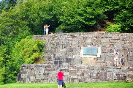

 Don't do that.

Waterfalls:

Every year, we hear of yet another death on a Carolina waterfall. Warnings are everywhere--in waterfall books, on websites featuring area waterfalls, and often along the trail.


 By now, everyone in the South should fully understand the dangers of climbing on and around these beautiful cascades. The rocks aren't just wet. A slimy film of algae beneath the water makes them slippery. And yet every year, someone climbs a waterfall or strolls along the top and falls. We witnessed such an event during our visit to Deep Creek. 

The photo below is dark because I didn't have time to set it up properly. If you look in the upper left of Tom Branch Falls, you'll see a young man climbing on the rocks. A young lady is sitting on a ledge on the lower right.


 Here's a normal photo of the falls for scale. 


The young man was almost to the top when he slipped and landed on the ledge near the girl. He survived, but a snap we heard indicated he may have injured himself. Still, ego or pride compelled him to consider trying it again. Pain, the crowd that had formed along the banks, or perhaps me loudly asking my husband to talk some sense into the kid changed his mind. 

He isn't alone. During our visit to Laurel Falls one year, we saw this upon our arrival. The falls continue just below that edge.


My Own Mistake

I've always wanted to ride a bike along the Blue Ridge Parkway, so during our visit to Cherokee, I did so. It was all downhill, and I was a little concerned about picking up speed during the ride, but I didn't want to pass up the chance. So we decided I would just ride my bike from one overlook to the next with my husband following behind in the car.

I never had to pedal. Between the grade and the curves, I suddenly found myself soaring down the Parkway.


Look closely at the photo. I may look like I'm taking a leisurely ride, but wind is billowing through my clothes. I was terrified. Why? I felt every tiny little bump or deviation in the asphalt beneath my tires, and several times, I felt the tire slip when I hit something. When we reached the tunnel I had forgotten about, I pulled off the side of the road. Unfortunately, several cars were tailgating my husband and he was unable to stop. That left me to travel through the dark tunnel without backup and ample reflectors. So unless you're an experienced biker or well prepared, you might want to find a section of the Parkway that's flat.

As I have mentioned in several posts and one television interview, thanks to a plethora of lawsuits and regulations, people are accustomed to walking in buildings, homes, and along streets with a reasonable assumption of safety. However, the great outdoors doesn't care about safety or liability. It has its own rules and it's up to us to follow them. Use wisdom and common sense. Go and have fun, but don't take chances that may injure or kill.

Part II of the WYFF Sound Off South Interview

Click here for Part I


And the answers I wanted to give. As you can see, I'm better with a pen:

What are your top three destinations in NC?

1. Anything Blue Ridge Parkway. We've driven the entire road.

2. Pisgah National Forest

3. We haven't decided on a coastal favorite yet; we're still learning our way around. So far, it's between Lake Mattamuskeet and New Bern.

However, we haven't explored the Piedmont yet, though after researching a few potential destinations, I've stopped referring to it as the land between me and the mountains.

What would you say is a rare jewel in the Carolinas?

I automatically pictured the swamp at Cypress Gardens, the marshes at Cape Romain, and the haunting forest of Congaree, but then remembered the view from the end of Table Rock's Summit Trail, and Pearson Falls in Saluda. [And I failed to mention Pretty Place and places along the Outer Banks.]

However, we've yet to see spider lilies blanketing parts of Landsford Canal State Park, to stroll the pristine shores of Bulls Island, see the view from Jumping Off Rock, watch snow geese swirl over the pocosin lake at sunrise, or witness the wonder of sea turtles hatching before they make their way into the silvery ocean. So I think the best answer is the Carolinas themselves, since they're home to all of these.

Is there anything else you'd like to add?

As often as I can, I include warnings about dangers, both hidden and visible, one may encounter. We're so accustomed to walking around city streets and inside buildings, expecting care has been taken to ensure our safety. But as I've mentioned in several posts, nature doesn't care about liability, and when people steps in its boundaries, they do so at their own risk. Having learned the hard way, we tell people to watch out for snakes and other critters--including bears. To watch where they walk (rocks, holes and tree roots often litter trails), to make sure they fill out hiker registration forms available at many trailheads, and tell someone where they're going and what time they should return home. Take plenty of water, and wear appropriate clothing. I can't tell you how many people we've seen hiking Table Rock with purses and sandals. Heed warnings listed on websites or posted at the destination. Use common sense.

Above all, don't play near the edge of cliffs or on wet rocks around waterfalls. Have fun, but be careful. We want people to enjoy the Carolinas, but we want them to go home safely so they can return again.

----------------------

Thanks for sharing this event with me. In my mind, it isn't about us and our talent or work, it's about showcasing the wonders of the Carolinas, which we hope to continually explore, and to share with you.

Table Rock State Park, SC


Our favorite hike in the Upstate.

Table Rock State Park is located off Hwy 11 in Pickens County. If you're coming from Greenville, travel up Hwy 25 and turn left on Hwy 11. This road seems to end, but turn right at the T-intersection (still Hwy 11.) Several miles down the road and past Hwy 276, you'll see the Visitor's Center on the left across from the mountain. Stop here to use the facilities and to take photos. To reach the trailhead and camping area, take the entrance to the right. There is a small fee to enter the park.

Pass the camping area and drive until you reach a parking lot located near the lake. Park here and walk across the street to the Nature Center.

Copyright 2012 Kimberli Buffaloe

NOTE: Restrooms are located in a wooden building off the far end of the park lot across from the lake and at the Nature Center. Consider using them before you start your hike. The trails are often crowded, and there aren't many places to sneak off to relieve yourself along the way.

After you leave the Nature Center, cross over the bridge but stop at the main trailhead and fill out the Hiker Registration form. I cannot express how important this is. On our first visit to Table Rock, we saw paramedics load a hiker onto a stretcher. Later, during a chat with a park ranger we during our hike, we learned hikers are injured every year when they take chances along the trail, underestimate their ability to hike, or when they slip on rocks or trip on exposed tree roots. My husband cracked his tailbone in a fall on the Carrick Creek Trail. Injuries do happen, and rangers need to know the general vicinity in which you'll be hiking and the time you left in the event they find your abandoned car. Please, fill out this form before you begin your hike.

Copyright 2012 Kimberli Buffaloe
Next, head toward the trail through a shady area alongside a creek that will tempt you to stay where you are. The presence of several small cascades are inviting, and you'll find yourself lagging behind, enjoying the beauty and serenity the view brings.

If you make it past the falls, you'll reach a juncture where the trails branch off. There are several trails to choose from, including a segment of the Foothills Trail. The shortest trail is Carrick Creek. The toughest, from what I understand, is the Pinnacle Mountain (not counting the Foothill Trails.) Know where you're going before you reach the park, give yourself plenty of time, and be prepared for a rugged hike. The Summit Trail is particularly strenuous, yet people attempt to hike it in wearing street sandals and hauling purses or babies.

As with all hikes, carry recommended equipment including (not limited to) a first aid kit, a flashlight in case you get stuck after dark, a compass, and plenty of water and/or Gatorade. On our first attempt to hike the Summit Trail, I took one 16-oz bottle of water. It wasn't enough and I ended up offering a park ranger $100 for a drink of her water. No kidding. Good ranger that she was, she handed over the water and refused the money. I now take ten bottles (total) of water and Gatorade whenever I hike this trail. Yes, it's heavy, but I overheat easily. The trail is strenuous and it's important to stay hydrated. A walking stick is also quite helpful on these trails.

Why bother? It's a great hike with fabulous views.


When out in nature, please be careful. So often we're accustomed to walking around streets and in buildings knowing we can generally tread without injuring ourselves. Nature has its own rules and it doesn't care about liability. Please watch where you're walking and stay off precipices and rocks in creeks. Don't take chances. Hike smart so you can return to hike another day.

Hike, but Stay Hydrated!

While taking a short (2.7 mile) walk one morning during the Texas-style heat wave that recently struck the southeast, I re-lived an important lesson I thought I learned during my first hike in South Carolina: when involved in outdoor activities, one must stay hydrated.

Granted, I started the walk on the thirsty side, but we travel this route a couple times a week without consuming any liquids. Plus, I'd trekked four miles at Medoc Mountain (report forthcoming) the previous week on only one little bottle of Gatorade, so I dismissed my need for water on this occasion.

Mistake. I had to cut the walk down to 2.2 miles and I still barely made it home. My Desktop Weather Channel severe weather alert told me why. During prolonged periods of intense heat, one is more likely to become dehydrated.

I contacted friend, fellow hiker, and nurse, Brenda Wiley, and posed the question about necessary fluid intake. Her knowledge and subsequent research revealed some interested facts. In addition to the standard "equivalent of eight glasses a day (64 oz) in food and water when consuming 2000 calories/day", she discovered urine color is an excellent indication of hydration--a hydrated person usually has clear, pale yellow urine. Thirst is another. The Institute of Medicine of the National Institutes of Science "indicates thirst is an acceptable guide for controlling (fluid intake)".

Oh my. I guess Sprite's copyrighted, trademark logo is right: Obey Your Thirst. (People in humid areas, that goes doubly for you. We learned that lesson in Kauai.)

Always check with your doctor to learn more about these issues, and especially if you're experiencing unusual or constant dehydration. If you've had your physical and everything is hunky-dory, then consume plenty of fluids during the day, and especially before you engage in outdoor activities. And if you're thirsty, even a little bit, for Pete's sake, drink something before you go outside. I almost ended up flat-faced on the side of a country road because I didn't. What would have happened if the same occurred during that four-mile hike at Medoc Mountain? I hope I never find out.

Buckhorn Gap Trail - Pisgah National Forest

I'm not sure how to approach this trip report. I don't feel like writing it with a humorous twist because in the end, it wasn't funny. But I can't get overly dramatic because for the most part, we enjoyed ourselves and we did survive. I'll just stick with the facts. Read carefully.

Our original plan was to follow the lead of another member of our hiking group and go to Little Glassy Mountain, but after a problem filled week at work I needed something a little more secluded, someplace where problems and a cell phone signal couldn't find me. This little tidbit will come into play later in the story.

I picked up Kevin Adam's Best Wildflower Hikes in NC and flipped through it until I came across Hike #47—Twin Falls in Pisgah National Forest. It sounded perfect. After making sure we had EVERYTHING under the sun except for a jacket because it was warm outside and a manageable map because I had Mr. Adam's book, we left. Unfortunately, that was around noon. That was our first mistake.

FR 477 or Avery Creek Road, the road that leads to Buckhorn Gap Trail (the trail that takes you to Twin Falls) is located just past the Pisgah National Forest’s visitor's center on Highway 276. It's a road I'm sure we've seen in the past, but we totally ignored, so when we turned and saw the sign announcing the road was closed 1.75 miles down near the stables, we decided to explore it anyway. After all, it's in Pisgah. It had to be interesting.

It was. We stopped several times to check out the campsites along the road or the clear water running through Avery creek. We weren't in the mood to leave, so we decided to hike along 477. As we were grabbing packs and walking sticks, two hikers returned from the direction we were about to head in and mentioned the trailhead wasn't very far. It was getting late but a quick glance at our watch told us we had another three and a half hours of daylight left, so we decided to hike to the falls anyway. That was our next mistake.

This was by far the most scenic trail we've been on this winter. It follows Avery Creek for awhile but then branches off and follows another white-water, cascade filled creek.

It had rained the day before, consequently, the trail was drenched and we walked through mud, soggy leaves, and pools of water as we went. There was water everywhere. Part of the trail was washed out in one spot and just impassable in another. We held onto trees as we skirted around the muddy bog. I kept wondering what it looked like when the flowers were blooming.

We reached the falls around four o'clock and spent as much time as we dared enjoying the view. But time was running out so we left. Because I didn't feel like hiking with Mr. Adam's book, I left it in the car. Another mistake. The result of that decision was our getting turned around a bit and heading in the wrong direction after leaving the falls.

I was sure the trail was a loop, so we kept on walking, certain we'd reach 477 soon. We reached a gravel road, which make hiking easier. But about an hour later, night fell. We pulled out our flashlights and when we reached a Y-Junction that had absolutely no markings on it, we decided to back track.

We were at an elevation somewhere in the vicinity of 2,600 feet. It was cold on that mountain and we didn't have a jacket, but as long as we moved, we were okay. It was also dark. We had two flashlights, but the batteries in mine were weak, and soon after, the light faded. I walked behind my husband as close as I dared, but the darkness swallowed the light and I could barely see. Back tracking the remainder of the trail was out: after we left the falls, we'd climbed a hill with an elevation of around 1,400 feet. We'd have to make our way down that hill in the dark, and if we did make it, the trail below it was confusing. If we missed one of those orange blazes, we would be lost in the Pisgah National Forest.

We were obviously lost, but what could we do without a map? We reached the gravel road and stopped at the point where the Black Mountain Trail intersected with Buckhorn Gap to regroup our thoughts and to make a plan. The cold began settling in our bones. We saw a sign for a trailside shelter. Kelley searched for it, but couldn't find it. He rejoined me where I stood in the dark, and finally, the realization that we were in big, big trouble sank in.

Late Afternoon Rays Indicate Trouble Is Ahead

I carried a Cobra hand radio in my pack, so I tried to contact someone to find out how far we were from the trailhead. No answer. I shouted into the darkness. No answer. We both tried using our cell phones. No signal. We were stuck in the dark on a mountain in the cold and we were lost.

Why didn't you build a fire? You might ask. We could have, but keep in mind this is January. The sun set around 5:30 or 6:00. We were facing twelve hours of darkness. It takes a lot of kindling and firewood to keep one warm for that amount of time, and to collect it meant risking a fall down steep slopes hidden in the darkness. We were also in the middle of a drought, and while it had rained, we had no guarantees that it rained there. We were surrounded by trees with nothing but leafy ground cover under our feet.

We finally realized we wouldn't make it through the night. We were about to die.

We had a lot of sweet moments in the time that followed, and we didn't hesitate to say how much we loved each other and how blessed we were to have the other in our lives. Surprisingly, I wasn't scared. I was on the trail with my husband, and I knew where I was going. It was okay.

We didn't give up though. At times I shouted (I have a really big voice), and Kelley still sought solutions. I tried my cell phone again, trying this spot and then another. And with my phone (not Kelley's, for I tried) and while standing on one spot, I was finally able to reach 911. We shared our predicament. They took the info and said they'd call back. An hour later, with my phone and on that spot, I called back. As it turns out, they'd been trying to call me but couldn't get through.

I should take a moment to mention that I have an old Nokia phone. I need a new one, but I refused to give up this particular phone because Nicholas Sparks used it to say Happy Birthday to my daughter during one of his book signings. No way I was going to give it up. Because of that, my old dual-band phone was able to reach 911 in a forest which, according to rescuers, has only 11% cell coverage. God does indeed work in mysterious ways.

Two hours after we called for help, two ATV's and a pickup arrived. We then learned we were three miles from the trailhead. If we'd had a map, we would have known the gravel road we'd stopped on led back to the stables. That may have helped, we don't know. It took a half hour to drive down it, so there's no telling what would have happened to us while walking in the dark.

We arrived at our car at 10:oo PM. The temperature at the stables where the Brevard Rescue squad had set up rescue operations was 43 degrees.

Lesson learned: No hikes over two miles during the winter. We start early, make sure we have flashlights with fresh batteries, proper clothing, and those little silver emergency blankets. Most important, we don't assume we'll be okay just because we hike frequently.

Buckhorn Gap is an attractive trail, and with Twin Falls waiting for you at the end, a hike well worth the effort, but take a map with you and stay aware. Learn from our mistakes and hike smart.