I'm not one to redirect readers to another trail report--I prefer passing along my own observations--but while investigating the mystery of why a sign points hikers to a trail located to the immediate left of a kiosk at the McAfee trailhead when the actual trail is across the four-lane highway, I found this well-written report on Hiking Upward, a site you'll want to bookmark. Having taken this hike, I agree with everything the author says (including advice on the return route, though I did not measure the various distances stated, so I cannot confirm those) with the exception of the total miles. From everything I've read, the trail is 3.9 miles one way, though at times, it felt like 4.4.
http://www.hikingupward.com/JNF/McAfeeKnob/
Now, regarding the sign that points hikers to a trail located to the immediate left of the kiosk....After numerous online searches and an attempt to contact the Appalachian Trail Conservancy via Facebook (in their defense, thanks to Facebook's message set up, I doubt they know they received a message), I called the AT's Virginia office located in Blacksburg and spoke to an AT champion there. According to her, the Conservancy is aware of that path, which was likely created over time by hikers going the wrong way or who needed a restroom break before heading on to McAfee Knob. They're aware of its existence and are working on clarifying for hikers the proper route to take.

A personal glimpse of outdoor destinations in and around the Carolinas. All photos and content copyrighted.
Showing posts with label Hiking (VA). Show all posts
Showing posts with label Hiking (VA). Show all posts
Cascade Falls, Virginia
Before our first visit to Roanoke, we contacted an acquaintance in that town and asked for recommendations of places to visit. She gave us several, and at the top of the list was Cascade Falls, located in Jefferson National forest just outside of Pembroke, VA.
It's a popular destination despite the two-mile hike (one way) along Little Stony Creek with good reason. No matter which direction you view it from, it's gorgeous.

Directions to Cascade Falls are found online at www.roanokeoutside.com/cascade-falls-trail and in Kevin Adams' Waterfalls of Virginia and West Virginia (page 58). It's important to note the Marathon station mentioned in the first set of directions is no longer there. At the time of this writing, the gas station is called Liberty. Because of that, we missed the turn and drove west for several miles. If you're unfamiliar with the area, we recommend setting your GPS to the intersection of Virginia Avenue and Cascades Dr. If you're coming in from the east (driving westbound) you'll see the gas station on the right and a bank on the left.
After stopping at the outfitter store housed in the gas station, (Tangent Outfitters at the time of this writing) which has a little bit of everything, we turned north on Cascade Dr and continued on for several miles. The road ends at the parking lot for the falls, where we paid a small fee and set off down the trail.
Just past the trailhead, hikers have two options: the scenic route and the fast one. Cross the bridge to hike along Little Stony Creek, where you'll hear the bubbling of water rushing over boulders in the stream and see peaceful cascades.


It's a popular destination despite the two-mile hike (one way) along Little Stony Creek with good reason. No matter which direction you view it from, it's gorgeous.

After stopping at the outfitter store housed in the gas station, (Tangent Outfitters at the time of this writing) which has a little bit of everything, we turned north on Cascade Dr and continued on for several miles. The road ends at the parking lot for the falls, where we paid a small fee and set off down the trail.
Just past the trailhead, hikers have two options: the scenic route and the fast one. Cross the bridge to hike along Little Stony Creek, where you'll hear the bubbling of water rushing over boulders in the stream and see peaceful cascades.
 |
| Copyright 2013 K Buffaloe |
 |
| Copyright 2013 K Buffaloe |

Approximately one mile later, hikers can cross another bridge. If one turns back here, it makes a two-mile loop. But continue on to the falls, which are hidden from view by boulders. Just past the opening, the scene is breathtaking. Sit and relax at one of the overlooks and enjoy the view. While we were there, several people swam or waded in the pool of water, and others edged close to the falls despite signs warning them not to.
As always, don't climb on rocks around waterfalls and always be careful when stepping on rocks in and around streams, even if they look dry. In a breath of time, your feet can easily slide out from beneath you, and you won't realize it until you hit the water--or the rock.

As I mentioned earlier, hikers have two options at the first bridge: the scenic route along Little Stony Creek, and option two, a gravel road that ascends to a path leading to the falls. If you're not in the mood for hiking over rocks and roots (see photo to the right) option two is the way to go.
The total length of the hike is just short of four miles, so take plenty of water and a snack, and give yourself time to hike the entire trail.
To the lovely couple we met at the overlook, thank you for allowing me to "steal" your scenery for a time. It was a pleasure to meet you. We enjoyed our chat.
And Gina, thanks for the recommendations. We've grown quite fond of the Roanoke area, and we hope to cross off everything on the list you gave us.
And Gina, thanks for the recommendations. We've grown quite fond of the Roanoke area, and we hope to cross off everything on the list you gave us.
Next up: Roanoke, McAfee Knob
Beaver Lake Trail, Pocahontas State Park (VA)
On occasion, we like to stray over the border to see what's happening at the neighbor's house. I'm growing fond of Virginia, so last week, we paid a call to Pocahontas State Park, located just southwest of Richmond.
Built by the Civilian Conservation Corps and donated to the state park system in 19461—a museum stands within the boundaries in its honor—the park has over seven thousand acres and two lakes. As we soon learned, popular activities in this largely forested recreation area include hiking, biking, camping, swimming, and picnicking. Since Churchill Downs is a tad bit too far, bridle trails are available for those seeking a place to let their horses stretch their legs.
Our first stop: a small building just inside the park that houses the office/visitors center/gift shop. There, we picked up a trail map and a brochure that served as park map and facilities guide, and asked questions. The first being, "Which is the most popular hike?" The answer? The 2.56 mile Beaver Lake Trail.
With good reason.
 The trailhead for the Beaver Lake Trail, among others, is located near the CCC museum, a quaint log cabin surrounded by tall trees and at least one azalea. After strolling a short distance down the path, we spotted Beaver Lake, two canoes, and a floating L-shaped boardwalk.
Canada geese honked from a grassy area near the middle of the lake, and a chorus of frogs churged from lily pads nearby. My husband spotted bass, crappy, and blue gill in the brown water. A serene picture we couldn't completely capture with our Nikon.


And apparently, beavers do live there.
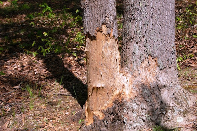
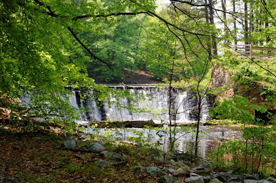
I had a sinking feeling, not related to the floating walkway, that this would be the best of the trail, but as we moved on, the park proved me wrong. A short distance from the boardwalk, water rushed over a man-made spillway, creating an attractive cascade. We stopped at various angles to enjoy the sight.


From this point, the trail branched into the woods, though we were never too far from the lake. We immediately noticed the absence of pine trees, so prevalent in eastern North Carolina ("and the idea occurs to me that it is no wonder we are called 'Tar Heels". -2nd Lieutenant William B. A. Lowrance [1863]2). Instead of pine straw, fallen leaves, brown and mottled, covered the forest floor. Sunlight streamed through the leafy branches of tulip poplars, sweet gum and more, giving the woods a green hue, like the atmosphere just after a rain.


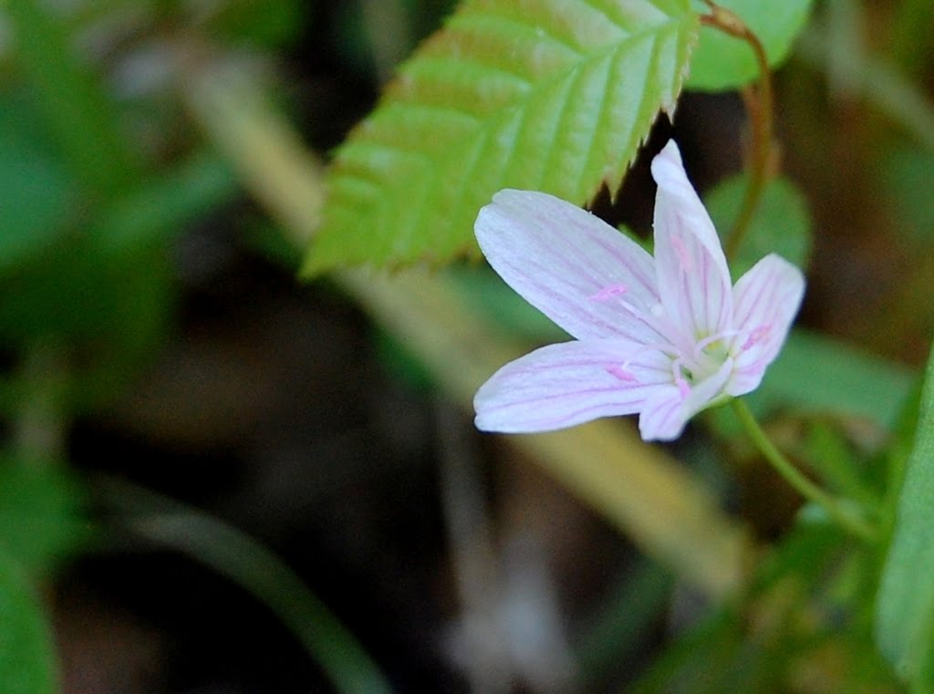
We crossed several short bridges, and a boardwalk over wetlands where Jack-in-the-Pulpits were said to grow. There, and in various places along the trail, we spotted violets, spring beauties, blueberry bushes. Ferns covered several gully slopes. Delicate wildflowers decorated the foliage in the wetlands like baby breaths in a bride's hair.


Stopping as we did to explore all this, we managed to turn a two-and-a-half mile hike into a two-hour outing. Fortunately, we had water and snacks in our packs. Visitors, I recommend at least that and bug spray.
Pocahontas State Park is located at 10301 State Park Rd, Chesterfield. There is a small entry fee. Camping, equestrian and other fees apply. For more information on fees, the park, camping, swimming, or canoe rentals, go to www.dcr.virginia.gov/state_parks/poc.shtml
1 http://www.dcr.virginia.gov/state_parks/poc.shtml#specialfeatures
2. http://ncrec.dcr.state.nc.us/Cat/CatServer.asp?WCI=MainEp&WCE=CatV1&WCU=509.16
Built by the Civilian Conservation Corps and donated to the state park system in 19461—a museum stands within the boundaries in its honor—the park has over seven thousand acres and two lakes. As we soon learned, popular activities in this largely forested recreation area include hiking, biking, camping, swimming, and picnicking. Since Churchill Downs is a tad bit too far, bridle trails are available for those seeking a place to let their horses stretch their legs.
Our first stop: a small building just inside the park that houses the office/visitors center/gift shop. There, we picked up a trail map and a brochure that served as park map and facilities guide, and asked questions. The first being, "Which is the most popular hike?" The answer? The 2.56 mile Beaver Lake Trail.
With good reason.

Canada geese honked from a grassy area near the middle of the lake, and a chorus of frogs churged from lily pads nearby. My husband spotted bass, crappy, and blue gill in the brown water. A serene picture we couldn't completely capture with our Nikon.


And apparently, beavers do live there.

I had a sinking feeling, not related to the floating walkway, that this would be the best of the trail, but as we moved on, the park proved me wrong. A short distance from the boardwalk, water rushed over a man-made spillway, creating an attractive cascade. We stopped at various angles to enjoy the sight.


From this point, the trail branched into the woods, though we were never too far from the lake. We immediately noticed the absence of pine trees, so prevalent in eastern North Carolina ("and the idea occurs to me that it is no wonder we are called 'Tar Heels". -2nd Lieutenant William B. A. Lowrance [1863]2). Instead of pine straw, fallen leaves, brown and mottled, covered the forest floor. Sunlight streamed through the leafy branches of tulip poplars, sweet gum and more, giving the woods a green hue, like the atmosphere just after a rain.


We crossed several short bridges, and a boardwalk over wetlands where Jack-in-the-Pulpits were said to grow. There, and in various places along the trail, we spotted violets, spring beauties, blueberry bushes. Ferns covered several gully slopes. Delicate wildflowers decorated the foliage in the wetlands like baby breaths in a bride's hair.


Stopping as we did to explore all this, we managed to turn a two-and-a-half mile hike into a two-hour outing. Fortunately, we had water and snacks in our packs. Visitors, I recommend at least that and bug spray.
Pocahontas State Park is located at 10301 State Park Rd, Chesterfield. There is a small entry fee. Camping, equestrian and other fees apply. For more information on fees, the park, camping, swimming, or canoe rentals, go to www.dcr.virginia.gov/state_parks/poc.shtml
1 http://www.dcr.virginia.gov/state_parks/poc.shtml#specialfeatures
2. http://ncrec.dcr.state.nc.us/Cat/CatServer.asp?WCI=MainEp&WCE=CatV1&WCU=509.16
Subscribe to:
Posts (Atom)