Pages

Showing posts with label Lighthouses. Show all posts

Hunting Island State Park

The ACE is the land within the horseshoe formed by the Ashepoo, Combahee, and Edisto rivers. Carolina Bays pock the northern section of the region1, but along the coast, waterways twist and wind, branching and spreading into the land like tree roots. It is, as the Marine Resources Research Institute calls it, a land of "sea islands, marsh islands, and barrier islands that are interlaced by estuaries, extensive salt marshes, intertidal areas, and oyster reefs."1 The result? Islands spaced beside one another like pieces of a jigsaw puzzle in progress. In an odd coincident, in places, the topography somewhat resembles this canopy of pine that we spotted along the trail:


Within this "Sea Island Complex"1 is Hunting Island. Once a hunting ground for private citizens3, this lush barrier island is now a state park, and it was the first stop on our ACE tour.

Having visited Hunting Island SP in 2005 or 2006, going in we knew to expect a Visitor's Center with a pond and real-live Lowcountry alligator, a marshwalk, and a beautiful lighthouse. We found all but the alligator, but spent little time at most of these attractions. Our goal for this trip was to learn more about the park, and to do so by hiking.

Hunting Island SP has several hiking trails. Two main trails form a long oval, with smaller trails connecting the two at various intervals. From the Visitor's Center, we started on the Maritime Forest Trail, a mixed forest of palmettos and pines, moss-covered oaks twisted with time, with a forest floor covered with what looked like fan palms.


About a quarter mile into the hike, we cut to our left, to the Lagoon Trail. This path runs parallel to a man-made lagoon, where we spotted a pelican flying overhead. A scenic stop on this very scenic route.


We continued on toward the cabins. While at the Visitor's Center, I learned the park no longer accepts reservations for the cabins, as the erosion so prevalent in the coast is quickly claiming the area around the structures. In Coastal South Carolina, Terrance Zepke indicates Hunting Island is eroding both at the northern tip of the island, and at the central beach. Before reaching the path that would take us to the cabins, we cut to the right, crossed the road, and took a tour of the Marshwalk.


Once past the gazebo, we continued on to the tidal creek, where we watched egrets soar over the marsh.


We doubled back and took the Maritime Forest Trail, searching for wildlife as we hiked back to our car. SC's state park site states Hunting Island has "an array of wildlife, ranging from loggerhead sea turtles to painted buntings, barracudas to sea horses, alligators, pelicans, dolphins and deer, raccoons, Eastern diamondback rattlesnakes and even the rare coral snake (I did not know that). We saw an abundance of squirrels, a pelican, and a lone woodpecker. But the forest was a sight to see, and we enjoyed our time on the trail.

But our time at Hunting Island wasn't over. We couldn't leave without seeing the lighthouse.


According to Zepke's Lighthouses of the Carolinas, this structure was built in 1875, and was moved once to avoid erosion. Today, visitors not terrified of heights can walk to the top of the lighthouse for a small fee.

In addition to hiking, boating, bike riding, camping, picnicking, kayaking, or spending time on the beach are other activities one can enjoy at Hunting Island State Park.


1. http://www.dnr.sc.gov/marine/mrri/acechar/esenviro.htm
2. http://www.beaufortcountylibrary.org/htdocs-sirsi/sea.htm 
3. Coastal South Carolina: Welcome to the Lowcountry, Zepke Terrance (Pineapple Press, 2006) p 217 

Cape Lookout Lighthouse and the Ponies of Shackleford Banks

In the past year, we tried to travel to Shackleford Island on two occasions. But since it's accessible only by boat, conditions have to be right. And in the past, the imminent threat of rain canceled our plans. With only a 30% chance on this day, we took a risk and traveled Downeast.

To my knowledge, one can catch a ferry to Shackleford and nearby Cape Lookout from Beaufort, NC, and Harkers Island. We tried Beaufort first. The operator I checked with had two options: a trip to Shackleford, where we would have been dropped off and picked up when we wanted, or a trip to Cape Lookout Lighthouse. I wanted both.

Since reservations were required for the Lookout trip, we headed to Harkers Island, to the Local Yokel ferry service. Funny name, good service. While they also offered a trip to Cape Lookout, they travel on the sound side of Shackleford Banks. When I told them I wanted to see the horses, they said no problem.

Cape Lookout National Seashore and Shackleford Banks form a check-mark at the bottom of the string of barrier islands known as the Outer Banks. After paying the $15 per person (read the rest of this post before you dismiss that as being too costly for such an outing), we climbed aboard the ferry and began our journey across the Core Sound.

And what a journey it was. We flew across the sapphire water, skirting shoals that gave this area the nickname, Graveyard of the Atlantic. True to the ferry operator's word, we saw some of the Shackleford ponies on the way to our destination. We'll get to those in a minute.

CAPE LOOKOUT

According to Lighthouses of the Carolinas, the present Cape Lookout Lighthouse was built in 1859, and the original keepers had to lug heavy containers of oil 163 feet up to keep the light burning.
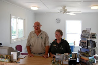
Today, a 1st-order Fresnel lens guide mariners around the shoals, and the lighthouse keepers have been replaced by volunteers who donate their time greeting guests and manning the Visitors Center. We met two such volunteers, Mack and Alice, from Salem, Virginia, and spent a fair amount of time chatting with them about the lighthouse and the volunteers' role at Cape Lookout. I applaud them, and the rest of the park's volunteers for braving the elements to keep this treasured landmark running.

Mack and Alice at Cape Lookout's Visitors Center
We spent a couple hours exploring the area around the lighthouse, the sea-oat and flower covered dunes, and the Lighthouse Keeper's House:

Copyright K Buffaloe

Copyright K Buffaloe
FINALLY, THE PONIES

The ferry arrived on time, and we began the journey back to Harkers Island. As with the trip over, we saw a few of the magnificent Shackleford Island horses, whose origin on the island is unknown, grazing in the marsh. And this time, the dear fellow from Local Yokel (who, btw, is anything but) positioned the ferry to enhance the view:

Copyright K Buffaloe

What a sight. What a birthday.

For more information on Cape Lookout Lighthouse, go to www.nps.gov/calo/index.htm

For more info on Shackleford Banks, go to www.originaldowneast.com/shackleford.htm

---------------------
Copyright 2009 All Rights Reserved. Do not use or distribute text or images without written permission.

Currituck Banks and Jockey's Ridge State Park

For the past year, we've been exploring eastern NC from the Fall Zone to the shores just off the Outer Banks. We've learned quite a bit during our outings. However, drawing on a quote I once read (the author of which I cannot remember) we've been jumping from parapet to parapet, and after a year of this, it was time to slow down and explore the castle's nooks and crannies.

We recently attempted to do that with a trip to Currituck Banks. It's a three and a half hour drive for us, so to maximize our time, we drove up on a Thursday evening and spent the night in Kitty Hawk. Depending on the hotel, the rates are fabulous on the Outer Banks right now, and we snagged a room for less than seventy dollars using our AAA discount.

The goal for this trip: explore Currituck National Wildlife Refuge and see the wild horses that roam the northern tip of the Outer Banks. Easier said. Hwy 12 ends at a beach, which is the entrance for the refuge. I presumed the sand would be packed down because this is the only way into the refuge and people have been driving on it for years.

Wrong. The sand is soft and deeply rutted, and after dishing out over a hundred dollars to fix our four wheel drive after the Mattamuskeet incident, Kelley was a bit nervous about attempting an off-road expedition. We gave it a shot, though. But when the ruts got deeper (and without our CarolinasAdventure posse there to push if we got stuck) we turned around.

The good news: various tours are available. I'd checked out the Jeep tours but they were too expensive for our current budget. Kayaking, and guided van tours are also available. This place is worth exploring, so we intend to return in the spring and take one of those tours.

Once back on paved ground, we stopped at the Currituck Banks National Estuarine Research Reserve, located within a few steps of the refuge's beach entrance. I'd read about this place in The Natural Traveler: Along North Carolina's Coast and knew we'd find a .33 mile boardwalk through the maritime forest that grows along the Outer Banks. Not what we had in mind but it would do.

To our delight, halfway down the boardwalk we found a mile and a half (round trip) nature trail that leads into a forest consisting predominantly of wax myrtle and live oaks, transitioning to pine near the water. The live oaks in this forest are amazing. Long, thin arms rest their elbows on the ground and then twist imploringly into the sky. The trunked sculptures stretched outward throughout the woods, pushing back other trees and providing space that allowed the winter light to shine through.

Blue blazes mark the trail. Note, we believe at least one sign is missing at a turn, and it gets a bit confusing in this area. If this happens to you, stop or backtrack if you can and look carefully. You should spot the blue-tipped stick a bit further down the path.

While enjoying the walk through the quiet forest, we came upon a pile of horse excrement. This often happens along a trail so I didn't think anything of it. By the forth pile, I finally caught on. Be still my Carolina heart, the wild horses roam through that area! Unfortunately, we didn't see any while hiking, or at the end of the trail where it meets Currituck Sound, but we saw plenty of evidence of their existence in that area.

After finishing that trail, we continued down the boardwalk to the observation platform overlooking marshes, Currituck Sound, and Monkey Island. The Estuarine is a good example of several types of natural environments: maritime forest, transitional forest, swamp, and marsh. From Natural Traveler, I learned North Carolina has four types of marshes: freshwater, brackish water, high saltwater and low saltwater. The marsh of Currituck Sound is an example of a low marsh, which floods daily with the tides. No wonder it's a research area!

Next, we made a quick stop at Currituck Lighthouse, situated in historic Corolla Village. After moving to ENC, I learned the four lighthouses of the OBX are similar in design, down to the wood and stone pilings they're built on. They're painted with different patterns so approaching mariners could distinguish one from the other. The Lighthouse Board left Currituck au naturale. The theory is this was to avoid having to paint it in the future. It was a good decision. Though built in 1875, Currituck is an attractive structure.

With time on our hands after not exploring the refuge, we made an unexpected stop at Jockey's Ridge, located in Nags Head. With its desert ambiance, tall dunes, wildlife that often roams the sand, and sparse vegetation, this destination deserves its own blog post. But more research and another visit is needed before I can attempt that. For now, I'll say that though around four hundred and twenty acres, the park is larger than I expected. Kelley hiked on while I stopped and took pictures, and at times, he was a speck atop the sand. Can you spot him in this photo?

At the top of that ridge, we were treated to a breathtaking view of a shaft of sunlight slicing across Currituck Sound. That view along with the 360 perspective makes the effort worth the climb. This being the highest spot, I assume it's also used for hang gliding and sandboarding, which are permissible under certain circumstances. The park has a hang gliding school, but I'll save that for the next post.

There are two "trails" at Jockey's Ridge: the one-mile Soundside Natural Trail, and the one-and-a-half mile Tracks in the Sand. But with all that sand, it's hard to tell exactly where the path is. We simply walked toward our destination.

As an added bonus, Jockey's Ridge runs perpendicular to the path of the sun and the shifting shadows along the dunes would make for some interesting photography in the early morning or late in the afternoon. Yes, we're definitely going back.

All in all a decent day despite not seeing the Outer Bank ponies.

So whether you're looking for a vacation spot or a nice getaway, the northern tip of the Outer Banks around Nags Head and Corolla is a great place to go. There's much to see and in the low season, hotel prices can be quite reasonable. Hope to see you there.

Bodie Island Lighthouse

Lighthouses of the Outer Banks is another subject I've been avoiding. Not because we haven't seen any--we've visited three of the structures since our arrival (four if you count the one we saw in the distance.) But when I sat down to pen a post, I realized I knew precious little about them besides the fact they're tall and they shine or shone light across the water to guide mariners home.

But there's more. The NC coast is known as the Graveyard of the Atlantic and there are several lighthouses stationed along the Outer Banks and on the Crystal Coast. This led to several questions. What made the waters so dangerous and was there a design to the placement of the lighthouses? As I researched, I found some of the answers and then uncovered answers to questions I hadn't thought to ask. I learned a bit about the source of the bright shaft of guiding light, and the purpose of the various patterns painted on the lighthouses along the Outer Banks. I read about light stations (small versions, usually on a platform), the effect erosion and OBX shifting has had on the lighthouses, and more.

Attempting to cover all that will take days and a lot of blog space, so I'll share what I can and give you resources for the rest.

Bodie Island Lighthouse

We didn't know Bodie (pronounced body) Island Lighthouse existed until we saw it a few miles south of where Hwy 64 meets Hwy 12 (the road that runs south along the OBX.) We've been twice and so far, it's one of our favorite lighthouses. Not because it's more attractive than the others--its beauty easily matches Hatteras--but because of it's location and the presence of marshes just behind it.

After turning onto the road that leads from Hwy 12 to the parking lot, we stopped and marveled at the sight before us. The lighthouse is located in a field just off the parking lot allowing the one hundred and fifty-plus foot structure to tower over its visitors. We spent several minutes taking photos, then meandered across the football-sized field to the lighthouse.

With its broad, horizontal black bands, Bodie is easily distinguishable from its coastal brethren--which authorities intended when they chose that design. What you see today is actually the third Bodie Island Lighthouse. The first had to be rebuilt almost as soon as it was finished due to structural deficiencies. The second was demolished when Union Forces visited the Outer Banks uninvited during the War Between the States. According to various sources, the third and thus far final Bodie Island Lighthouse was built shortly after 1872.

The small structure you see in the photo (in front of the lighthouse) was once used to store oil for the lamp that created Bodie's beam, but since its replacement, the original 1st-order Fresnel Lens that now lights the way, works on a photocell, the structure is empty. The lighthouse is opened to the public on occasion, but to my knowledge, only to look inside. Climbing the metal steps is not permitted.

That's okay with me.

As I mentioned earlier, a portion of the Outer Banks' estuary system is located behind the lighthouse. I walked along a boardwalk past tall grass, reading placards on plant life and nutria along the way, and stopped at an wooden observation platform. A large flock of white birds floated in the distance and I watched them until I was certain they had no intention of flying or coming closer so I could get a photo.


Migratory birds floating in the water off to the right of the photo

Bodie is in good shape, so it's a favored subject of photographers and painters. However, because of it's beauty and accessibility, it's difficult to take a photo of the lighthouse without capturing tourists as well. If you can't visit during low season or on a weekday in spring when your odds are better, have patience. On both trips, we managed a few shots sans tourist just by waiting.

The old lighthouse keepers house is also located on the premises, and serves as a Visitor's Center and a bookstore (which we frequent when we can. You did receive the Bodie Island notecard I sent, right??) For more information on Bodie Island Lighthouse, go to:

Carolinalights.com
National Park Service's Bodie Island webpage
Lighthouses of the Outer Banks

A book I purchased to study for this blog post is Lighthouses of the Carolinas: A Short History and Guide by Terrance Zepke.

So why the need for so many lighthouses along the coast? To learn about the Graveyard of the Atlantic, click HERE