Pages

Showing posts with label Western NC. Show all posts

Cherokee

Nestled in tall peaks at the southern terminus of the Smoky Mountains where the Oconaluftee River flows, is a land once occupied by a people whose right to occupy it permanently was later won harder than the nation in which it was formed.

Our first visit to this area was in the early 1990s. We had driven to Clingman's Dome and curious as to what lay on the other side of the great mountain range, we continued on. I remember little of what we discovered was a reservation. Just a teepee on the side of the road and a shop where my husband purchased a knife he still uses. Minutes later, we left and for the first time, drove along the Blue Ridge Parkway, which begins on Hwy 441 just south of the Smokies.

Over a decade later, we moved back to South Carolina, and as I had during our first residency in that state, I devoured as much history as I could.

Once again, Cherokee crossed my path. This time in, Bushwackers, by William R. Trotter. Certainly I had learned about the Trail of Tears in school, but this beautifully-written book of the bloody War of Secession in the Blue Ridge Mountains reminded me of, and expanded on, what I had learned. I read about the Cherokee Nation, of those who escaped the forced relocation, and those who later fought in Thomas's Legion, and the fight to create a reservation on land once occupied by the Cherokee.

Years later--just a month ago--I downloaded The History of the Upper County of South Carolina by John H. Logan. In it, Logan mentions several Indian nations, but he focuses on the Cherokee in particular, painting them not as the mystical people they're too often viewed as today, but as people. Noble and strong, but as people who went about their business in a way different to what the settlers were accustomed. An astute and beautiful people, who, among other tasks, hunted and fished, built structures from logs, and "who made gloves and shoes" from the hides of panther. People who wronged and were wronged. Who routinely slaughtered and who were slaughtered. Of everything I had read to date, Logan (and at times Bartram, who Logan quotes) put a face on the Cherokee people.

Suddenly, Cherokee was everywhere: in my readings, in recent news articles, and featured on various This Day in North Carolina History posts. So when I extended our upcoming vacation to Bryson City by a day, I booked a room in Cherokee.

Cherokee, NC is located within what is called the Qualla Boundary, the tract of land that is the Cherokee reservation. The tourist influence is evident in shops that sell crafts, pottery, and moccasins, though the casino presence was far more obscure than I had expected. But with a thick forest and nearby peaks, there is a beauty here. Long cane still grows along the river as it did before the settlers arrived, and the clear water of the Oconaluftee still swirls over boulders in a shallow flow. Those these days, you'll likely find locals and tourists riding down the river on colorful, inflatable tubes.

Cherokee is ideally located at the southern boundary of both the Smoky Mountains and the Blue Ridge Parkway, and it's one of the gateways to Bryson City. The people of Cherokee invite you to visit the Oconaluftee Village, where descendants of those who escaped the Trail of Tears present the Cherokee way of life as it was hundreds of years ago. The outdoor drama, Unto these Hills, presents their heartache of the Trail of Tears. You'll also find a golf course, fishing, and Mingo and Soco Falls.

Cherokee welcomes visitors. They invite people to come and enjoy this beautiful region they call home, to learn about their heritage and to know at the end of the day, this is still the land of the Cherokee.


A big shout out to Tanya for her assistance on this trip, and for the great conversations we had about the Cherokee.

Pearson Falls: Updated over the Years

Years ago, I wrote about Pearson Falls after the first of many visits: Pearson Falls, Saluda NC

Nearly seven years after leaving the Upstate, we returned to Pearson Falls. Much is the same--the short trail is still serene; wildflowers still grow along the lush path; the falls are still gorgeous--but the Tryon Garden Club has made a few changes. The nominal entry fee has risen a few dollars, funds which keep the falls open to the public and which are used for improvements. Upon our arrival, we spotted a small cafe (closed this early in the season) and newly-constructed restrooms.

As always, we enjoyed our time at this North Carolina treasure. For more information, go to http://pearsonsfalls.org/


Waterfalling in Brevard

We recently traveled to the charming town of Brevard, North Carolina to enjoy a few days in the mountains and to introduce friends to the "Land of a Thousand Waterfalls".

Our first stop was Dupont State Forest. Land protected from residential development, Dupont is home to five impressive waterfalls, and we walked the wide, gravel road to three.

The aptly named High Falls. Note the edge of the Covered Bridge, shown below, peeking from the trees above the falls, and the people at the lower right of the base.


Hooker Falls


And Grassy Creek Falls


As I mentioned above, the land was saved from residential development, and wide gravel paths like streets wind through the forest. In addition to road signs marking trails, visitors are also treated to the sight of a covered bridge.


We didn't have the opportunity to visit Triple Falls or Bridal Veil Falls on this trip, but we had plenty of waterfalls to explore outside of Dupont. We introduced our friends to the wildly popular Looking Glass Falls, located alongside Highway 276 in nearby Pisgah Forest.


Because chilly temperatures had turned the mist to ice along the walkway, we kept out distance from the base.

Next, we stopped by Connestee Falls, located in Brevard.

This photo doesn't begin to show the powerful stream of water gushing beside the observation deck toward the cascade. Though visitors can no longer get close to the falls, or down to the base, the observation deck is a short walk from the parking lot and a nice stop if you're in the area.

Since we were so close to the South Carolina border, I couldn't resist going to Caesars Head State Park. I love the view from the escarpment.

As an added bonus, we stopped by a chapel I've long wanted to see. Nicknamed Pretty Place, the YMCA Camp Greenville's Symmes Chapel is a favorite stop for many.

As the saying goes, if you're lucky enough to live in the mountains, you're lucky enough. And we were blessed with a few days in the Land of a Thousand Waterfalls.

Grandfather Mountain Part II: Geology

Okay, I have avoided this subject for as long as possible. Geology is often difficult to understand, but to really appreciate Grandfather Mountain, visitors must at least give the subject a cursory glance because Grandfather Mountain is geology. It's conglomerate rocks, outcroppings and rock that gives the appearance of having been melted (this isn't the technical term, but how I viewed it). And when I read about Grandfather Mountain and geology, I come upon phrases such as rift basins, crustal sheets. thrust faults and geological window.

Here's what the park has to say on the subject: www.grandfather.com/worldofwonder/geology/

I'll just say that Grandfather Mountain has some pretty neat rocks, and not just the promontories that contribute to the famous profile.

Copyright 2012 K. Buffaloe
Shortly after entering the park, vistors approached two large boulders, commonly referred to as Split Rock and Sphinx Rock. Both are conglomerate rock which, according to Exploring the Geology of the Carolinas, is formed from various rock types including flattened pebbles. Significant in that it shows the rock has been metamorphosed (changed by heat and pressure).

Copyright 2012 K. Buffaloe
Larger than they appear!

Copyright 2012 K. Buffaloe
Closeup of the pebbles and rock that form these boulders:

Copyright 2012 K. Buffaloe
The rock at the Swinging Bridge is also conglomerate rock, but appears melted in some places, angular in others, providing dramatic, dynamic views.

Copyright 2012 K. Buffaloe


Copyright 2012 K. Buffaloe


Copyright 2012 K. Buffaloe

Copyright 2012 K. Buffaloe
And of course:

Copyright 2012 K. Buffaloe
So while admiring the incredible views from Grandfather Mountain, don't forget to examing the geological significant rock beneath your feet.

For more information, check out the chapter on Grandfather Mountain in Exploring the Geology of the Carolinas by Kevin G. Steward and Mary-Russell Roberson.

Grandfather Mountain Part I: The Summit

For some, the mention of Grandfather Mountain calls to mind the Mile-High Bridge, the animal habitat, and an imposing granite profile perched atop a mountain. Others know the mountain more for its history or geology. Whatever the interest, Grandfather Mountain is a state treasure, and one of North Carolina's newest state parks.

We recently traveled to Boone, NC to visit Grandfather Mountain. One of two destinations along the Blue Ridge Parkway we've passed far too many times, though not for lack of interest. Shortly after moving to the Carolinas, one look at the iconic photo of a man standing near the precipice overlooking a sea of white clouds, and then reading about the mountain in connection with the infamous Union guerrilla, Keith Blaylock, convinced me to visit. But between my fear of heights and an entrance fee, we shoved Grandfather Mountain to the bottom of the To-See list. After all, I could never cross that bridge, so why bother paying the price?

As I learned, for several reasons.

We began our visit at the entrance on US 221. After paying the entry fee, a bit less than we expected thanks to a AAA discount, we received a brochure and an audio CD that, with amazing timing, guided us up the road to the top of the mountain. We paid close attention, noting what we would return to, and where we would stop during our ascent (more on that later). But our main goal was the peak that for so many years, I longed to visit.

Our drive ended in the parking lot of the Top Shop, where a blast of cold wind curled around us and nearly knocked us off our feet as we stepped out of the car. The weather is unpredictable at the summit, so much so, weather equipment is attached to the bridge, so bring a warm jacket regardless of the season. Inside Top Shop, a gift shop and gateway to the Mile-High Bridge and that famous peak, I purchased a warm knit cap and we took the elevator to the upper deck where an inspiring view captivated me.

Copyright 2012 K Buffaloe
It was inspiring, I crossed that bridge despite my fear. I had to. It called me to, asking how could I come that far and not walk to that peak?

It helped that the bridge spans an 80-foot gorge, not a mile of empty space. The bridge is simply a mile above sea level. As we soon discovered, in the middle of the bridge near the mile marker, the wind whistles through the metal slats resulting in an ethereal song heard only by those who dare to cross. On this day, that would be me.

Why did the chicken cross the road? To see the view from the other side!
But the singing bridge and panoramic view wasn't all there was to see. As I mentioned earlier, Grandfather Mountain has a unique geology, easily visible to guests, which I'll discuss in my next post.

For more information on Grandfather Mountain, go to http://www.grandfather.com/

For a current view of Grandfather Mountain, check out the High Country Webcam:
http://www.highcountrywebcams.com/webcameras_grandfather.htm

An Hour on the Blue Ridge Parkway

Last week, we traveled to the mountains of North Carolina for overdue visits to destinations treasured to the state. Shortly after arriving, we hopped on the Blue Ridge Parkway to soak in much-missed scenery. Trillium and other spring wildflowers grew along the road and storm clouds cleared just enough to form a rainbow, visible from an overlook. A beautiful evening along the Blue Ridge Parkway.

Copyright 2012 K. L. Buffaloe

Copyright 2012 K. Buffaloe

Copyright 2012 K. Buffaloe
 
Copyright 2012 K Buffaloe
In upcoming posts, I'll share a bit about the Moses H. Cone Memorial Park and Grandfather Mountain. Yes, I crossed that bridge when I came to it. You should have heard it sing.

Jump Off Rock, Laurel Park, NC

Jump Off Rock, near Hendersonville, NC (not to be confused with Jumping Off Rock near SC's Lake Jocassee) offers a great view of the Blue Ridge Mountains just yards from the street.

From Hwy 64 in Hendersonville, we went south on Main St then right on 5th, just past The Mast General Store. A few stoplights later, 5th St changes to Laurel Park Highway, and we twisted and wound along the two-lane road as it gained elevation. At the end, the road split into a small loop. Here, we parked and took the pathway to the rock outcropping known as Jump Off Rock.

Short walk from the street to Jump Off
Copyright 2011 K Buffaloe
Jump Off Rock
Copyright 2011 K Buffaloe
While the outcropping is called Jump Off, please don't! According to several sources, the destination derives its name from the legend of a young native who supposedly jumped after receiving word of her love's death. Instead, take a moment to enjoy the panoramic view, which includes Cold Mountain, and Mount Pisgah.

View from Jump Off Rock. For a larger image, click on the photo.
Copyright 2011 K Buffaloe
There are three hiking trails near Jump Off Rock. We were unable to explore any of the trails on this trip, but plan to when we return. A sign on the premises states visitors are to hike at their own risk, so use the utmost caution while on the trails.

For more information on Jump Off Rock, go to www.historichendersonville.org/jump_off_rock.htm

Well, That's New....

I love it when I learn about a "new" Carolina destination. While playing with Google Earth the other night, I found a photo of Hibriten Mountain in Lenoir, NC. Total news to me, so I did a search and learned Hibriten is located in the Brushy Mountain Range, a tendril of the Blue Ridge Mountain.

Fantastic! But do they have trails? According to Mountainzone.com, several trails are nearby, including the Lovers Leap Loop Trail, and the AT. Oh my.

It appears trails are either for mountain bikers or hikers (no indication they're shared), are within four miles of the Brushy Mountain Summit, and range from 1.6 to 13.6 miles (Paint Rock Mountain Biking Trail). For more information, check out the following link:

www.mountainzone.com/mountains/detail.asp?fid=1660856

And for more information on Hibriten Mountain, go to: www.mountainzone.com/mountains/detail.asp?fid=6300356 

Because that's about all I can find on it.

I guess we'll just have to check it out ourselves.

Glen Burney Trail, Blowing Rock

During our trip to NC's High Country, we wanted to cram in as many state parks and hikes as we could during our few days there. To help us decide which and where, we brought along Kevin Adams' North Carolina Waterfalls and Best Wildflower Hikes, exploring north carolina's natural areas (not a typo, it isn't capped on the book, either) and North Carolina State Parks, A Niche Guide.

Having spent part of our time at Mt. Mitchell and Linville Falls, we looked for something near Blowing Rock, our headquarters during this trip. With its gables, rocking chairs, and flowers galore (we even spotted one growing in a crack in the sidewalk) Blowing Rock is as charming as it is trendy, so we were surprised to find a hefty little two-plus mile (round trip, longer if you hike beyond the falls) mountain hike within city limits.

I don't recommend this trail for anyone with mobility issues or small children. We had assumed the trail was named in honor of one Glen Burney, but halfway through the hike, we realized Glen was an actual glen, Webster's definition of which is a secluded narrow valley. While the secluded part only applied to the latter part of the trail—we were within city limits, and for a time, spotted houses, manholes in the path, pipes and other manmade features—narrow was right on, and steep at parts, making this a moderate-to-strenuous hike. The falls themselves can be quite dangerous as well, but more on that later.

Down we descended, down rock steps, over narrow portions of the trail, through an explosion of rhododendrons, fighting high humidity that thickened as we descended into the valley, toward not one, but three cascades:


Rhodos everywhere:


Though we took this photo on our way back up the trail, the first waterfall we passed was the Cascades:


Again, we took the following photo on our way back to the trailhead. But this, as with the photos above, shows what we encountered as we hiked down the trail.


Sign for Glen Burney Falls. We splintered off the main trail and descended a bit further into the glen.


Glen Burney Falls isn't tall, but it's attractive on a small scale despite the log:


From there, we continued to Glen Marie Falls, barely visible from a side view:


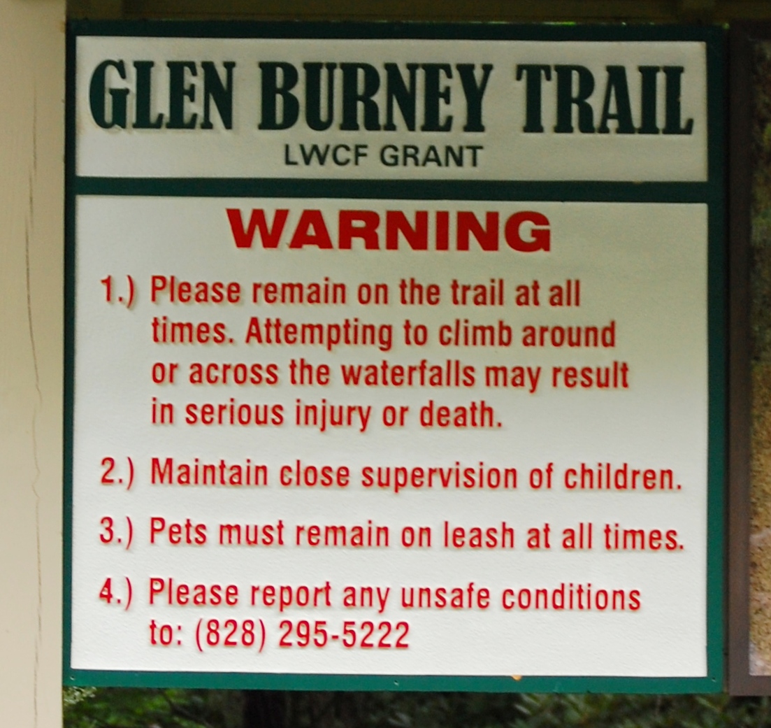
And situations like this often lead to danger. Kevin Adam includes a strong note of caution about these falls in his Glen Burney Falls entry (pg 81). There are signs at the trailhead and along the trail:


Yet despite these warnings, people are injured because of the very nature of the falls. You noticed how difficult it is to see Glen Marie. Because of that, people are tempted to walk out on the large boulder beside it for a better view. But remember, the water descends into a glen, and those rocks at the falls keep on going—straight down.


The photo above show the continuation of Glen Burney Falls. We couldn't capture the sharp, 75-foot descent onto additional boulders at Glen Marie because of vegetation.

While discussing the trail with a clerk at our hotel, she mentioned a friend of hers had been injured at one of these falls. "I don't the trail is well maintained," she said. I told her it was. The problem lies in the fact people ignore the signs. My husband, moving slow and confidently, did so and took a risk despite the warnings in an effort to take a better photo of Glen Marie. I want to keep him around for years to come, so I moved the camera far from his reach.

So please, if you hike the Glen Burney Trail, stay on the trail and off of rocks. At Glen Marie, stay behind what my husband called the "trip line" (hard to see, and just high enough to trip over).

After taking photos of the final falls and the Rattlesnake Plantain Orchids we found growing nearby, we headed back to the parking lot.

A note on the directions. According to Kevin Adam's book, to reach the trail, turn onto Laurel Lane from Main Street in downtown Blowing Rock, and drive 0.1 mile to the parking area at Annie L. Cannon Memorial Gardens. However, at what appears to be the end of Laurel Lane you'll find both a stop sign and a parking garage. This isn't your destination!

Turn right at the stop sign and then, almost immediately, turn left into the open parking lot at the Gardens.


Across the street and to the left, you should see this:


See? Charming. 

Linville Falls

Our first stop of the day took us to Mt Mitchell, the highest point in the east. The second, the deepest gorge in the east. And they're approximately forty-three miles apart along the Blue Ridge Parkway.

I've heard and read much about Linville Gorge and Falls. Members of my hiking group have ventured into the gorge and returned with exciting stories of strenuous hikes and photos of a vast, rugged wilderness—and, on occasion, an isolated field of daffodils. I shied away from the idea of navigating craggy rocks and steep cliffs but was equally curious about those formations, so different from the surrounding landscape. It's one of the reasons I purchased Exploring the Geology of the Carolinas (Steward and Robertson, UNC Press.) From the chapter on Linville Gorge, I learned the rocks in and around the falls are a spectacular example of a "tectonic window". A cross-section of a significant geologic event. No digging required!

More on that in a minute. As it turns out, there are several short (in hiker terms) stops along a trail that allow visitors to view Linville Falls from three different perspectives: eye level, high, and much higher. The trail difficulty is easy, difficult and tiring. After parking and making a short trip to the Visitors Center, we crossed a bridge. Following signs, we arrived at the first overview in just a few minutes.


Notice the rock in the photo above, and at the "observation" platform:


From here, the river glides through a small gorge carved by the current, much like water flows down a slide at a water park:


Then, the river twists and turns, and spills over yet another small cliff. We hiked along the Erwins View Trail to the Chimney View overlook, where both falls were visible:


Along with a different type of rock. See the difference?


We continued on up the trail to the Gorge View Overlook, which tested my fear of heights:


And then to the Erwins View Overlook, where I nearly ran back down the trail when a young man decided he had to take photos from the stone wall.


Please don't do that. There is an unobstructed view of the falls from the safer, far side of the overlook:


From there, we hiked back to the parking lot and the bottles of water we'd forgotten to bring along. Back at the hotel, I picked up Exploring the Geology of the Carolinas, and reviewed the chapter on Linville Falls. Had I read it in advance, I would have remembered the folded (melted looking) rock around the falls is actually older than the rock around the lower falls (photos 7 and 8). This is the result of a collision between plates.

Yes, that's right. We were looking at a fault! The authors of Exploring do a good job explaining the collision, the resulting thrust fault and the "shear zone" now visible. I highly recommend this book to those interested in the geology of the Carolinas. 

Time well spent along the Blue Ridge Parkway.