Pages

Showing posts with label Wildlife. Show all posts

What Not to Do in the Great Outdoors

It seems fine while you're there. Fun, even comical. But mistakes and missteps lead to injuries and deaths every year. But those are fools, right? Idiots. Not people like us.

Yes, people like us who are confident we know what we're doing. Even experienced hikers. It's the confidence that gets us. After witnessing a few mistakes during our vacation to Bryson City--and making one I never imagined would be that dangerous--I thought it best to share what not to do in the great outdoors.

Wildlife:

There is one hard and fast rule: Don't approach them. Just keep your distance. It's one thing to happen on them as we did a bear on a Deep Creek trail and these bikers did when they reached the end of the Blue Ridge Parkway.


It's another to stop and engage the animal as tourists did on the Laurel Falls trail during our visit one year. After seeing a bear, they actually chased it to get photos. Never, never, never chase a bear. When we spotted one on the Indian Creek Trail two months ago, we turned around and headed back to the trailhead. And when we encountered the elk in the photo above while riding our bikes to Mingus Mill, we kept our distance. Unlike the motorists in these cropped photos.


We related this tale to a park ranger shortly after this encounter, and he shook his head and told us the big elk in the photo has been known to ram vehicles during encounters such as this. Interaction with humans can also be dangerous for the animal. An elk had to be put down last year after he became too comfortable strolling up to humans. And if constantly fed, other wildlife such as bears no longer feed themselves. They also get a little too comfy ransacking campsites and the interior of cars in search of food.

Ledges and Precipices:

Would you stand on the edge of your roof to gaze upon your neighborhood or to take a selfie? People who can't hang Christmas lights on their house because of the height seem to have no trouble standing at the edge of precipices or on ledges in the great outdoors. I've lost track of the number of stories I've heard where people have plunged to their deaths. So when people decided to stand on the ledge of an overlook at Newfound Gap, we weren't the only ones concerned for their safety
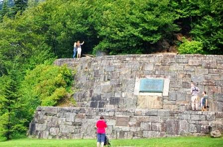

 Don't do that.

Waterfalls:

Every year, we hear of yet another death on a Carolina waterfall. Warnings are everywhere--in waterfall books, on websites featuring area waterfalls, and often along the trail.


 By now, everyone in the South should fully understand the dangers of climbing on and around these beautiful cascades. The rocks aren't just wet. A slimy film of algae beneath the water makes them slippery. And yet every year, someone climbs a waterfall or strolls along the top and falls. We witnessed such an event during our visit to Deep Creek. 

The photo below is dark because I didn't have time to set it up properly. If you look in the upper left of Tom Branch Falls, you'll see a young man climbing on the rocks. A young lady is sitting on a ledge on the lower right.


 Here's a normal photo of the falls for scale. 


The young man was almost to the top when he slipped and landed on the ledge near the girl. He survived, but a snap we heard indicated he may have injured himself. Still, ego or pride compelled him to consider trying it again. Pain, the crowd that had formed along the banks, or perhaps me loudly asking my husband to talk some sense into the kid changed his mind. 

He isn't alone. During our visit to Laurel Falls one year, we saw this upon our arrival. The falls continue just below that edge.


My Own Mistake

I've always wanted to ride a bike along the Blue Ridge Parkway, so during our visit to Cherokee, I did so. It was all downhill, and I was a little concerned about picking up speed during the ride, but I didn't want to pass up the chance. So we decided I would just ride my bike from one overlook to the next with my husband following behind in the car.

I never had to pedal. Between the grade and the curves, I suddenly found myself soaring down the Parkway.


Look closely at the photo. I may look like I'm taking a leisurely ride, but wind is billowing through my clothes. I was terrified. Why? I felt every tiny little bump or deviation in the asphalt beneath my tires, and several times, I felt the tire slip when I hit something. When we reached the tunnel I had forgotten about, I pulled off the side of the road. Unfortunately, several cars were tailgating my husband and he was unable to stop. That left me to travel through the dark tunnel without backup and ample reflectors. So unless you're an experienced biker or well prepared, you might want to find a section of the Parkway that's flat.

As I have mentioned in several posts and one television interview, thanks to a plethora of lawsuits and regulations, people are accustomed to walking in buildings, homes, and along streets with a reasonable assumption of safety. However, the great outdoors doesn't care about safety or liability. It has its own rules and it's up to us to follow them. Use wisdom and common sense. Go and have fun, but don't take chances that may injure or kill.

Outer Banks: An Overview

I've been procrastinating.

For months now, I've put off sharing a destination we first visited in December of last year and again this past May. Part of my problem has been determining the scope of what I should discuss. Our first trip to the Outer Banks (henceforth referred to as the OBX) encompassed the outskirts of Nags Head to Salvo and the second, from Kitty Hawk to Ocracoke. That's a lot of ground to cover. A lot of dunes, concurrent views of sound and sea. A lot of natural habitats to explore, outdoor recreation to draw your attention to, and oh, well you get the picture. Though harrowingly narrow in some places, the OBX is a lot of everything.

So I didn't cover anything.

But the time has come, so, after twittling with words for a couple of days, I've decided--like so many of our trips--to take off and see where we end up.

The Outer Banks

It wasn't our intent last winter to visit this North Carolina treasure. Our original goal was Edenton and Roanoke Island, but on our way to the second stop, a sign informed us Nags Head was a mere twenty miles away. How could we pass it up? So passing up the many attractions awaiting us at the site of the famous Lost Colony, we drove to the eastern edge of the United States and turned right. And to our delight, we were on the Outer Banks.

I'd heard about the OBX, but I knew little beyond what people had told me, that it's a great outdoor destination. If you look at a map of North Carolina, it's the sharp edge, the lip liner if you will, along the NC coast that juts to a point before scooping back to the mainland. Since our visit, I've learned it's more than that and I feel wholly inadequate to cover this fragile ecosystem/tourist destination. You'll understand why as you read.

The chain of islands known as the OBX begins around the Virginia/NC border, but I'm having trouble determining where it ends. Some sources say Ocracoke. Others include as far south as Bogue Banks. Personally, I include the entire archipelago from the Virginia border to Shackleford Island since I cannot see a difference between the northern section and the southern. NC may revoke my citizenship for that, but sorry, it's all breathtakingly beautiful to me.

Once on the OBX, one of the first things that struck me was the width. Though 175 miles long according to Encyclopedia.com (another source says 200 mi, see dispute listed above), it's narrow, earning it the nickname "Ribbon of Sand". Encyclopedia.com places the width at one mile or less and indeed, in some places, we saw both sound and ocean in the same glance:


See the touch of water on the upper right of the photo?

Since our first visit, I've learned more about the OBX (though not nearly enough.) First from a PBS documentary titled Ribbon of Sand, and then from various sources such as my copy of Coastal North Carolina: Its Enchanting Islands, Towns, and Communities. Enough to form a decent overview. Unfortunately, it's complicated, but I'll try to explain.

Think of long, thin islands, stretched in a line and joined together by bridges in some places, and by ferries in others.1 On the west side lay wide sounds. On the east, the Atlantic Ocean, and along some of its edges, swirling sandbars (shoals) visible on satellite photos but not to approaching ships. Traveling down Hwy 12 alongside tall dunes and under a sphere of blue sky gives you a feeling of freedom. You open the car window and take in the breeze and the view of herons walking dapperly in shallow waters.

You reach Rodanthe (ro-danth-ee, yes of Nicholas Sparks fame), see dozens of three story beach houses and you want to stay, but you travel on to Hatteras where you're delighted by the spiral banded lighthouse stretching regally into the sky and by boats drizzling through the water. You sit on the beach, hidden from civilization by an undisturbed dune and lay back in the sand, releasing a sigh of contentment. After a ferry ride to Ocracoke, Blackbeard's headquarters and the place of his infamous demise, you dine on local seafood, listening to tales of the pirate's ghost and wonder why you ever competed in the rat race.

That's one side of the OBX. Another is the dynamic, fragile environment. The ever-shifting coastline that's slowly eroding from waves, hurricanes, and development, which forced conservators to move the Cape Hatteras Lighthouse further inland.

The OBX has an extensive estuary system and such, hosts migratory birds. But it's also home to thousands of people whose livelihoods depend on tourism. Because of its compact width, man and nature must live together, and often, the needs of one clashes with the other. This past summer, authorities closed off several areas along the OBX because endangered birds were nesting, thus endangering businesses already hurting from high gas prices.

Saving one's job versus putting a near extinct bird in the air. Tough call. One I couldn't make.

There's more. Oh so much more. But I hope this gives you an adequate glimpse of the Outer Banks, its fragility, and its must-see beauty. In my next post, I'll discuss the lighthouses we saw this past year. The rest I'll have to cover in posts as we're able to return for additional visits. But I doubt I'll master all things OBX, there's too much to learn.

But I'll try.

For now, if you'd like more information on the OBX, go to http://www.outerbanks.org/

Also, check out UNC's book, Ribbon of Sand.


Post Script:

If you decide to travel to the Outer Banks, for land's sake, read my post on the Ferry schedule before you go. It may keep you from getting stuck on Ocracoke Island overnight and spending the night with a few OBX ghosts!
1. Coastal North Carolina: Its Enchanting Islands, Towns, and Communities (Pineapple Press) Pg 1

NC's Natural Communities, Part II: Lake Mattamuskeet

According to the University of North Carolina's, Documenting the South, John Lawson arrived near Bath, NC on February 24, 1701.1 Shortly after, he built a home near modern day New Bern. Since Mr. Lawson intended to survey the Carolinas, I can only believe he found his way to Lake Mattamuskeet, located just northeast of New Bern, across the Pamlico Sound. In his journal, A New Voyage to Carolina, he makes a reference to "(swans) which come in great Flocks in the Winter".2

It must have been a sight to behold. It is today. This past spring, a member of my hiking group mentioned the snow geese swirling over Mattamuskeet at sunrise and since then, I haven't been able to get that mesmerizing image out of my mind. Eastern NC CarolinasAdventurers discussed a January outing, but I couldn't wait. A week after visiting Green Swamp, my husband and I were standing on the shores of North Carolina's largest natural lake.


Over five miles wide, like Phelps and Pungo (also located on the Albemarle-Pamlico Peninsula) Lake Mattamuskeet is shallow, on average, just two feet deep.3 According to exploring north carolina's natural areas, it's also the largest Pocosin lake in the southeast United States.4 If you've seen a map of North Carolina, you've seen this lake—it looks like a hole punched out in the bottom of the raggedy middle flap of NC's coast.

Finding Mattamuskeet wasn't hard. We traveled east on Hwy 264 until we reached Hwy 94, then we turned left. Thankfully (for us, not the birds) this highway slices north-south through the center of the lake. We parked on a grassy shoulder a mile down the road and were promptly blown away. Hundreds of brown ducks that we mistook as broken wood or the bases of trees drifted in the shallow water near the shore. Shortly after, they took flight.


Beauty makes me weep, and the sight of that large flock flowing gracefully through the sky before us nearly brought me to tears. Only the unequivocal joy surging through me as I watched them and several herons lounging nearby kept the brine at bay.

Fifty-two pictures later, we resumed our journey, and for the next hour we observed and photographed more waterfowl than I've seen at one time: Blue Herons. White Herons. Canada Geese and a long stretch of birds floating a mile down the lake captivated us. We stopped at the observation pier, located near the midpoint of the road, and watched Tundra swans floating past an island of cypress trees, its knobby knees sticking up like a bed of nails. I jerked the car off the side of the road at my husband's command when we spotted herons perched in a tree. We photographed a clutch of herons standing in still waters, their reflections as clear and defined as the birds themselves. We continued on until hunger forced us to find food. 

Mattamuskeet is a must for bird and nature enthusiast, and anyone who loves beauty. And there's more to explore than what we saw. If you view the lake through Google Earth, you can see a jetty or boardwalk jutting into the water on the east side, and several small islands on the west. We'll have another chance, though. We still have that January outing, and I wouldn't be surprised if we slipped back there in December. Wouldn't you?

Sylvan Heights Waterfowl Park, Scotland Neck


"Where should we go today?"

One wouldn't expect the answer to be a waterfowl park, but if you live in eastern North Carolina, it should be.

My husband and I recently had the privilege of visiting the renowned Sylvan Heights Waterfowl Park in Scotland Neck, NC. I learned about Sylvan Heights from an article in the May 2008 issue of Wildlife in North Carolina magazine. I thought about visiting at that time, but a quick glance at an atlas led me to believe Scotland Neck was too far off the beaten path to bother with given today's gas prices. As it turns out, it's only eighteen miles from Halifax, located just off I-95 (south of Roanoke Rapids) and less than two hours from Goldsboro.

The Wildlife article did a wonderful job detailing the work Sylvan Heights owners, Mike and Ali Lubbock, are accomplishing. After seeing the place in person, I'm not sure it did justice to the park itself. The waterfowls reside on six "continents", conveniently situation near one another on a gently rolling hill. Visitors travel to each continent on wide, often shady gravel paths. Gates surround each area, and mesh forms a canopy above, preventing escapes. Visitors can walk through the gates and spent time watching, photographing, or feeding the birds before heading to the next continent. Traveling has never been easier.

Note: Duck food is available for a nominal fee at the Visitors Center. When feeding the birds, it's best to toss the nuggets to them. Some bite. If you're wearing sandals, beware! Besides the fact tiny bits of gravel from the path can slip in your sandal as you walk, toes can be mistaken for goodies. One Hawaiian Goose thought my stubby little toes were duck food! The pain was minimal, but my husband had a good chuckle over it.


Sylvan Heights didn't just happen, and the agrarian landscape of eastern NC isn't a spot one would expect to find a preservation effort of this nature and magnitude. The Lubbocks worked hard to create this sanctuary, and their passion is infectious. We had several discussions with Sylvan Heights employees during our visit, and their dedication to the over 2,000 birds (170 different species) at the park is evident. "A pure joy," one employee told several visitors. "I never get tired of it."

And it's in eastern North Carolina.

Admission is $7.00 per adult, $5.00 for children ages 3-12. Check their website for various school programs and discounts. We went on Teacher Appreciation Day. Next up--a special day for children of military members (go Sylvan.) They have an annual membership as well. In addition to unlimited admission to the park for the paid year, the membership fee includes two passes to the North Carolina Zoo.

Other great things about Sylvan: They have a yearly photo contest. Visitors, keep an eye on their website and submit your best waterfowl photo! They're also fixin to hold a photography workshop.