Pages

Showing posts with label waterfowl. Show all posts

Wildlife at Mattamuskeet

I have some information and photos of Jump Off Rock in Henversonville to pass along, but couldn't wait to share a few photos from our recent trip to Lake Mattamuskeet (the big hole in the flap of land along the NC coast.)


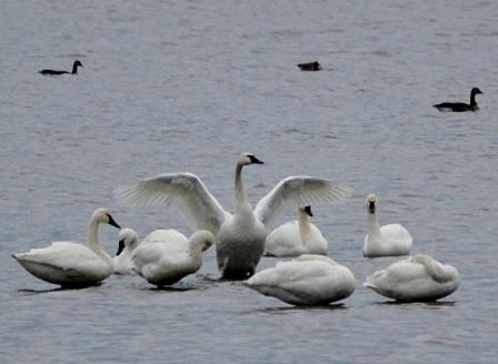
It's December, which means Tundra Swans, Snow and Canada geese, and thousands of other migrating waterfowl have stopped by the state to rest a spell before moving southward. Many of the birds were near the shore, so we had some great views. It's a long drive, but well worth the visit.


Panoramic shot of the cypress islands at Mattamuskeet:


The Return of the Swans

Sorry, but after reading @ (Swanquarter, Hyde Co, etc) recent Twitter tweet, I couldn't resist...

The snowy swan arched her wings and rising up, took flight. And soared across the tundra ice in search of warmer nights. Though weary from the journey of a thousand miles or more, she pressed on southward to her goal on Carolina shores.


At last! The oval lake of blue appeared within her sight. The snow swan then arched her wings and ended there her flight.


Landing in the shallow waters, she at a cypress moored.

And there she rested for a month on Carolina shores.


According to Inner Bank's tweet, the swans are back around Swanquarter and Lake Mattamuskeet. We'll be heading east in the near future!

A Final Look at Mattamuskeet

Okay, okay, okay, I know I've done the waterfowl thing to death, but the birds are amazing. And, when it's cold outside, one can view wildlife at Mattamuskeet from inside the warmth of the car—and it's been cold!

For that reason, we took one more trip to the amazing Lake Mattamuskeet before the 09-10 wintering waterfowl season ended. No snow geese (no surprise ) but we saw much as we drove along Hwy 94. Enjoy.


Pea Island National Wildlife Refuge

Most people think of the Outer Banks as a vacation spot, so many may be surprised to learn portions of the OBX are national wildlife refuges. Currituck NWR is located at the tip of the barrier chain, and in the middle, between Oregon Inlet and Rodanthe, you'll find Pea Island National Wildlife Refuge. This was our destination a few weeks ago, and you may wonder why given the cold snap North Carolina has been experiencing.

Because it's a great place to see wintering waterfowl!

After donning heavy coats, hats, and gloves, we grabbed our gear and set out on the three-hour drive. One travel option would have been the ferry from Swanquarter to Ocracoke (which would have allowed us to view even more waterfowl), but that particular route comes with a fee, so we traveled east on Highway 64. When we reached Hwy 12 on the OBX, like the birds we sought, we headed south.

From a past attempt to visit the refuge, I knew the visitor's center was located on the right side of the road, just a short distance south of the bridge spanning the Oregon Inlet. It was our first stop, and proved to be our best, for inside we met the Moores, who serve as volunteers for Pea Island. When we walked through the door, they greeted us with voices as warm as the interior of the spacious lobby/gift store, and we spent the next half hour or so talking, listening, and searching for birds they pointed out in the marshy areas of North Pond, located on the sound side of the OBX, through spotting scopes.

During our conversation, I mentioned our ultimate goal for this trip—to find the snow geese that had managed to elude us. With a smile, Neal Moore made us an offer we couldn't refuse: a guided tour to South Pond, just down the road from the visitor's center. By now I'm sure you know what we found:


Snow geese! And of course, Tundra swans:


It wasn't the thousands we'd heard about, but I wasn't complaining. When my fingers could no longer stand the brisk upper-20 temps, we headed back to the visitor's center, where we attempted to walk the North Pond Wildlife Trail, one of the many Charles Kuralt trails we've encountered in eastern NC. I had my eye on an observation platform visible from the visitor's center, and we hit the boardwalk, passing under a low canopy of tangled tree branches before cold air turned us around:


I later learned there are two trails at the refuge. The North Pond Trail, and Salt Flats, on the northern tip of North Pond. Pea Island is an excellent birding area, and the refuge has accommodated visitors while providing shelter for birds who need rest during their long journey south.

Pea Island NWR has over 5,800 acres (not counting water) on a stretch of land twelve miles long. In addition to playing host to migrating waterfowl, Pea Island sees its share of nesting sea turtles in the spring and summer. Oddly, it's also home to the Oriental, a steamer that sank off the shores of the OBX in 1862. Another gentleman at the visitor's center pointed us to a brochure that tells the story of the ship that fell prey to North Carolina's Graveyard of the Atlantic, and invited us to cross the street and traverse the dune to see the boiler which is still visible in the choppy waters. We declined on this trip, but as always, we have an excuse to return.

For more information on Pea Island, go to www.fws.gov/peaisland/ And if you're heading that way, don't forget to take your camera, binoculars, and plenty of warm clothes. A thermos of hot apple cider wouldn't hurt, either.

Our thanks to the Moores, especially Neal Moore, for serving as our guide on this trip.

Sylvan Heights: A Groundbreaking Experience

Last week, we traveled to Sylvan Heights Waterfowl Park to find a few wood ducks. We first visited this overlooked jewel last year after reading about it in Wildlife in North Carolina magazine. That trip was both pleasant and informative, and because of it, we expected to spent our day strolling around the shady forest-park, looking at ducks that couldn't fly away when we tried to photograph them. We got that and more.

To our surprise, one of the employees recognized us from our previous visit. I remembered her, too, because she spent time with several visitors, providing excellent information on many of the species living at Sylvan Heights, as well as on the park itself. After chatting for a few minutes, she invited us to a groundbreaking that would take place on the premises that afternoon.

As we soon discovered, the groundbreaking was for a ground breaking expansion. Sylvan Heights is building an accessible treehouse so that those with physical impairments may enjoy the park and its residents. Funded in part by several organizations both mentioned and represented at the event, the octagon-shaped "Bird's Nest" will overlook three levels of wetlands to be restored in the woods behind existing exhibits.

Wetlands restoration? Handicap-accessible facilities? Those in addition to working to save waterfowl? We were honored to witness the event:

The grand opening should be held this summer. We hope to be there for it.

Sylvan Heights is located in Scotland Neck, NC, approximately eighteen miles from historic Halifax. To keep up-to-date on the opening and other events at Sylvan Heights, visit their new blog at http://sylvanheightsblog.blogspot.com/

A delightful visit. But we didn't expect anything less.


If you missed the link to our first post, including photos, on Sylvan Heights, click here.

Pungo Lake (Part II)

(To read Part I, click here)

Main Entry: po•co•sin*
Pronunciation: pah-KOH-sen (my spelling)
Etymology: probably from Virginia or North Carolina Algonquian
: an upland swamp of the coastal plain of the southeastern United States

Like Phelps Lake, Lake Mattamuskeet, Alligator Lake (aka, New Lake) and the three lakes in Croatan National Forest, Pungo Lake is a pocosin lake, which means it's surrounded by thickets consisting mainly of short bay trees and shrubs with Latin names I can't pronounce. To give it a decidedly southern touch, Magnolia virginiana, or Sweetbay magnolia, grows in the midst.

In addition to being a pocosin, and possibly a Carolina Bay (the lake is elliptical like a bay), the 12,000 acres of what's referred to as the Pungo Unit is also a haven for wintering waterfowl. Thousands of ducks, geese, and swans—and I mean about 50,000 more than the number that just popped in your head—winter at Pungo. I understand that during the warmer months, black bears can also be spotted when they leave the protective confines of the woods to feed.

That's why, when the Navy decided to build an Outlying Landing Field within miles of the Pungo Unit, coastal NC residents went berserk. And I mean berserk in a good way. A grassroot organization instantly sprang up to defend the waterfowl. NO OLF signs appeared in store windows and in front yards. The case went to court. After a long fight for the birds, the birds won. In January of 2008, the Navy changed its mind.

But I promise you, there's still some fancy flying going on out there:

As I mentioned in my previous post, we finally found the lake, but of course, we spotted only about a half dozen swans floating around. During an informative conversation with Gail and Steve, bird enthusiasts we met on the way to Pungo, we learned migrating waterfowl are all but gone by March. Along with a time frame to return next season, Gail suggested the best place to find those elusive snow geese is Pea Island National Wildlife Refuge, located on the Outer Banks. Indeed, a month or so before this we'd spotted a couple of white feathered fowl floating around the marshes near the Pea Island Visitor's Center before rain sent us home. In a voice filled with a sadness I've come to understand, Gail told us the number of snow geese has diminished greatly over the past decade. Once they "were all over, and walking in the road". But no more.

We spent some time there, enjoying the lake despite the high winds that day, and chatting with Gail and Steve. Then we left to find the second access road I spotted through Google Earth. We found it, but it was "Closed for Research". Since it appears a sandbar extends into the lake at that point, we'll return later and check it out.

Other Pungo facts:
  • Like the trails in the Alligator and Roanoke NWRs, a Charles Kuralt Trail kiosk has been erected in this refuge. We spotted it near the observation platform. I'm just learning about this trail system, but I did find a link to a website that explains what it is and why Mr. Kuralt's name is attached to it. For more information, go to http://www.northeast-nc.com/kuralt/
  • From what I can ascertain, hunting is allowed on the refuge (state rules and regulations apply). However, I've yet to find anything that indicates boating is permitted. The lake is smaller than Phelps and Mattamuskeet, and access is limited. Because it's a pocosin, the water is shallow. A ranger at the National Wildlife Refuge office estimated the lake is, on average, six to eight feet deep. So if you're hoping to spend the day on the water, this may not be the right destination for you.
  • According to The Natural Traveler: Along NC's Coast, the land was once owned by a commercial farming company. Remnants of their presence is visible in the grid of dirt roads and the deep canals running alongside them. While the roads are handy, the trip can be bumpy in dry weather, and deep and rutted when it's wet. Use caution. As the NC Birding Trail reminds visitors: if it's raining, you want want to reschedule your trip for another time. I would also suggest this to those considering a trip in the middle of the summer when NC bugs are out in full force.
  • The presence of farms inside Pungo Unit may confuse you. After all, this is a national refuge. As I've recently learned, the farms are part of the sanctuary. Farmers are permitted to grow crops, but they must leave twenty percent of the harvest behind for refuge animals. I'm sure the birds love this. We spotted plenty of them feasting on fallen grain.
After spending time enjoying the scenery, looking for birds, and chatting, we said our goodbyes. Steve and Gail left to find New Lake (Alligator Lake on some atlases) and we followed the road alongside Pungo, photographing mallards and a few other duck species as we went. Wouldn't you know it, we ended up at the same spot we stopped at last fall.
But we found the lake, and that's what's important. Another good day along the ENC coast.

Pungo Lake is a great destinations for birders and naturalists. If you're interested in seeing the lake, especially during the winter, grab a good atlas and match it up to these basic directions:

From the west: Travel Hwy 264 to Pantego. Left on 99, Right on 45, Left on Hyde Park Canal. When the pavement ends, keep on going until you hit the lake. If the road is closed like it was on the day we visited, turn left on the dirt road, travel about two miles, then turn right at the refuge sign. Turn right again at the end of that dirt road, and when you reach the dirt intersection, turn left over the stone culvert that crosses over the canal and go until you hit the lake.
Yes, it can be that confusing. Again, use caution.

For more information on Pocosin National Wildlife Refuge, go to:
http://www.fws.gov/pocosinlakes/


* http://www.m-w.com/

The Search for Pungo (Part I)

I can't give up. Even if a bout of frustration causes me to quit, rarely can I stop all efforts to achieve a goal. So it wasn't a surprise when, after our original outing plans fell through last week, I pulled up Mappoint and Google Earth and set out to find an access point to Pungo Lake.

Twice last year we tried to find this obscure body of water, and twice we failed. Once, our GPS indicated it was beside the dusty road on which we stood. Having seen it as a destination in my exploring north carolina book, as well as other resources, I knew it had to have an entrance. But where? After zooming in and scooting the image left, right, up and down on both digital maps, I found two potential access points to the lake. I set the GPS for one and my iTouch maps app for the other.

And we found it: http://tinyurl.com/PungoEntrances (click on aerial).

Pungo Lake is part of the 110,000+ acre Pocosin National Wildlife Refuge. The refuge is nestled between Highways 99 and 94, moving south from Phelps Lake, and extending to New Lake (a.k.a. Alligator Lake). Need a visual to get your bearings? Click here for a map.

If the refuge name sounds familiar, think back to the North Carolina wildfires of 2008. The pocosin forest just north of Pungo caught fire, which burned deep into the peat that makes up the forest floor. Though the wildfire blanketed the state with thick smoke (and chased us to Richmond, Virginia) I recently learned that, like the longleaf pine forest, fire is beneficial to this natural community. Many plant species that exists in a pocosin thrive from it.

But that's another natural communities blog post. For now, let's continue down the road.

The refuge, and thus Pungo Lake, is located on the Albemarle-Pamlico Peninsula. The large center "flap" on the coastal plains if you're looking at a map. On each of our visits, I'm struck by the order that now pervades a land once covered in tangled shrubs. Originally inhabited by Algonquin-speaking natives, and after years of rigorous taming, farmland, boxed off by deep ditches, creates a quilted look visible from plane windows or satellite images. Tilled rows lead the eye to a line of longleaf pines in the distance.

We had unexpected company on this trip. Following directions dished out by our GPS, we drove east on Hwy 264, then turned north on Hwy 99 in the heart of charming Pantego. After turning right onto Hwy 45, we spotted an impressive flock of large, white birds resting in the midst of winter wheat. Though we suspected we'd found more Tundra Swans--yet still hoping we'd found the elusive snow geese--we pulled off the road near a couple taking pictures beside a truck.

Yes, I have a picture, but I didn't know about it until we returned home. Therefore I didn't have a chance to secure permission to post it. Next time.

No one hauling kayaks and cameras on a Carolina trail is a stranger, so after taking pics of the *sighs* swans, we introduced ourselves to Steve and Gail, birders from the Durham area. Ironically, they were looking for Pungo.

They followed us, which, if you're a regular reading, you know isn't a good idea. Though I have maps galore and a good Carolina atlas, we often guess at a route or say "hey, I wonder where this goes". Apparently, my preparations and the routes we showed them on both machines convinced them we knew where we were going. Fortunately, it worked out this time (thank you, Lord) and before long, the four of us were standing on an observation platform staring at the gorgeous blue waters of Pungo Lake.


A Not Quite Stitched-Together View of Lake Pungo


Next Post: Pungo

NC's Natural Communities, Part II: Lake Mattamuskeet

According to the University of North Carolina's, Documenting the South, John Lawson arrived near Bath, NC on February 24, 1701.1 Shortly after, he built a home near modern day New Bern. Since Mr. Lawson intended to survey the Carolinas, I can only believe he found his way to Lake Mattamuskeet, located just northeast of New Bern, across the Pamlico Sound. In his journal, A New Voyage to Carolina, he makes a reference to "(swans) which come in great Flocks in the Winter".2

It must have been a sight to behold. It is today. This past spring, a member of my hiking group mentioned the snow geese swirling over Mattamuskeet at sunrise and since then, I haven't been able to get that mesmerizing image out of my mind. Eastern NC CarolinasAdventurers discussed a January outing, but I couldn't wait. A week after visiting Green Swamp, my husband and I were standing on the shores of North Carolina's largest natural lake.


Over five miles wide, like Phelps and Pungo (also located on the Albemarle-Pamlico Peninsula) Lake Mattamuskeet is shallow, on average, just two feet deep.3 According to exploring north carolina's natural areas, it's also the largest Pocosin lake in the southeast United States.4 If you've seen a map of North Carolina, you've seen this lake—it looks like a hole punched out in the bottom of the raggedy middle flap of NC's coast.

Finding Mattamuskeet wasn't hard. We traveled east on Hwy 264 until we reached Hwy 94, then we turned left. Thankfully (for us, not the birds) this highway slices north-south through the center of the lake. We parked on a grassy shoulder a mile down the road and were promptly blown away. Hundreds of brown ducks that we mistook as broken wood or the bases of trees drifted in the shallow water near the shore. Shortly after, they took flight.


Beauty makes me weep, and the sight of that large flock flowing gracefully through the sky before us nearly brought me to tears. Only the unequivocal joy surging through me as I watched them and several herons lounging nearby kept the brine at bay.

Fifty-two pictures later, we resumed our journey, and for the next hour we observed and photographed more waterfowl than I've seen at one time: Blue Herons. White Herons. Canada Geese and a long stretch of birds floating a mile down the lake captivated us. We stopped at the observation pier, located near the midpoint of the road, and watched Tundra swans floating past an island of cypress trees, its knobby knees sticking up like a bed of nails. I jerked the car off the side of the road at my husband's command when we spotted herons perched in a tree. We photographed a clutch of herons standing in still waters, their reflections as clear and defined as the birds themselves. We continued on until hunger forced us to find food. 

Mattamuskeet is a must for bird and nature enthusiast, and anyone who loves beauty. And there's more to explore than what we saw. If you view the lake through Google Earth, you can see a jetty or boardwalk jutting into the water on the east side, and several small islands on the west. We'll have another chance, though. We still have that January outing, and I wouldn't be surprised if we slipped back there in December. Wouldn't you?