
Raven Cliff Falls
One has two options for this hike ... a shorter 2 mile hike (one way) takes you to a delightful observation deck situated across the gorge from Raven Cliff Falls. The scene from the deck takes in the entire cliff that Matthews Creek drops over to create these falls.

If one is up to a longer half day hike, you can then continue another 2 miles beyond the observation deck, to hike to the falls themselves, situating the hiker on a most impressive swinging suspension bridge directly over the falls. From here, you can look across the gorge in the other direction, seeing the observation deck!

Either way, the hiking is quite easy, with no significantly steep trail sections. Of course, classifying a hike as easy/hard is quite subjective!! Researching trail books for this hike showed one listing the difficulty as easy, and one listed it as difficult!! So, look at the distance, look at the topo, and YOU decide!! In my book, given what most trails are like in this area of the mountains, this is easy!!

Both trails are part of the "Mountain Bridge" trail system. These trails go through a spectacular 40,000 acre area located in the northwestern corner of South Carolina, that "bridges" an area that includes Caesars Head State Park, Jones Gap State Park, and the protected watersheds of Table Rock and Poinsett reservoirs.
There are 17 trails throughout this area. A most useful resource is the "Guide to the Mountain Bridge Trail" publication, printed and distributed by Naturaland Trust, a non-profit land conservation organization located in Greenville, SC.
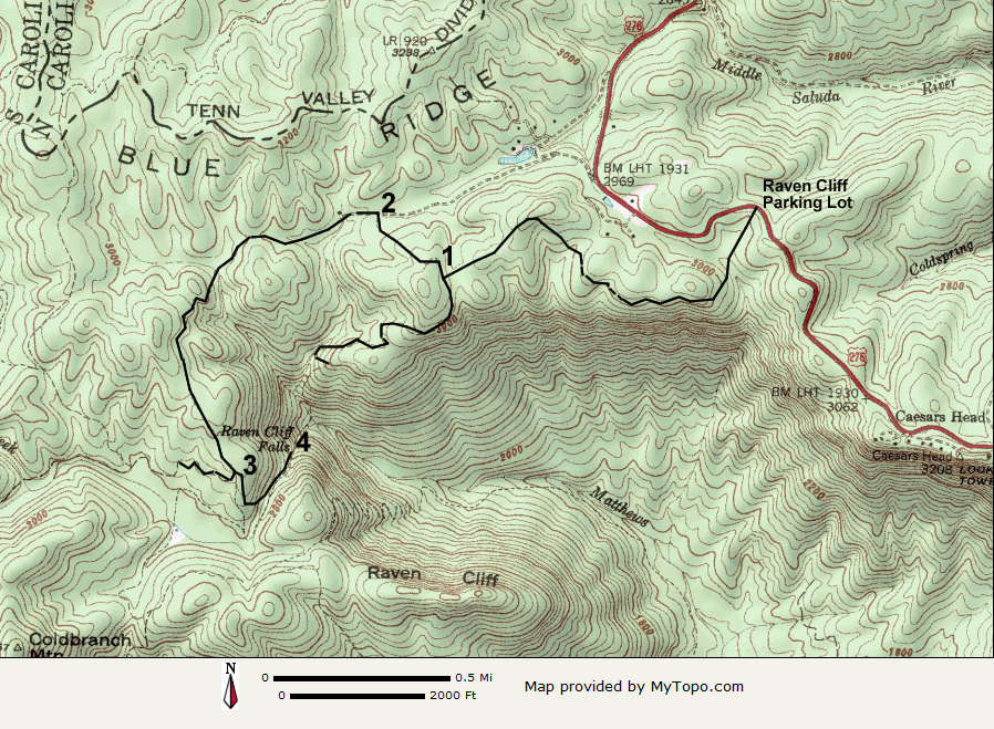
Access to both of these hikes is from the Raven Cliff Parking Lot, located on highway 276, 1.5 miles south of the North Carolina/South Carolina state line (one mile north of Caesars Head State Park).
The hardest part of the hike may be finding the parking lot ... while it is located right on the highway, it is significantly downhill from the highway and cannot be seen from it.
If coming from the north, watch for a sign for "Overnight Log Cabins" on your left, that is located right in a rather sharp right hand curve. Just ahead, you will see some split rail log fencing. The turn into the parking area is just before this fencing.
If coming from the south, you have an easier time: you will see the trails beginning clearly marked on the left, along with a painted white crosswalk across the road. Look for the split rail fencing, and turn right into the parking area.
South Carolina charges a $2.00 per person day use fee ($1.25 for SC residents 65 and older, disabled residents, and National Guard members), paid via the honor system by means of small envelopes located at each trail head, that are dropped into a lock box. This area's vast protected lands available for hiking are well worth paying for in my book, and I urge all users to contribute to the upkeep of these wonderful parks.
Once you've located the parking area and paid your fee, walk across highway 276 and begin your hike. {Note: Don't forget to fill out the hiker registration form located at the trailhead.}
 The trail begins as a gentle downhill walk, which gradually drops the hiker down approximately 200 feet in elevation, and brings you to the edge of a most compelling escarpment. Here, the Blue Ridge mountains drop a precipitous and impressive 2000 feet in elevation to meet the rolling hills of the Piedmont area of South Carolina.
Portion of the trail that runs along the escarpment
 Not only will you share the trail with other hikers, many of whom are accompanied by dogs, you might even see a hobbit or two!! I snapped photos of a hobbit hole found right along the trail!
Both the trail to the observation deck, as well as the trail to the falls themselves are very well marked, and due to their popularity, well worn and easy to follow. The trails are blazed, with blazes often every 100 feet or so. At major trail intersections, large informative trail boards are present.

After hiking 1.4 miles from the parking lot, the trail forks. The trail to the observation deck bears left, and the trail continuing to the falls goes right. A trail sign board is located here. (Location #1 on topo map)
To go to the observation deck, turn left and go another 0.6 mile, you'll reach the trails end at the deck itself. (You pass a turn off to the Dismal Trail, named for the area the trail passes through that is a dense, mature hardwood forest directly beneath Caesars Head.)
Once you arrive at the observation deck, a third of a mile or so (as the crow flies) straight ahead of you is the edge of Raven Cliff, and you can see Matthews Creek dropping over it forming these magnificent falls. If you look closely, you can see the swinging suspension bridge over the falls!
Arrow is pointing to the falls
At this point, one is faced with a decision. With just another 2.5 miles of hiking, one can be standing on the above mentioned swinging suspension bridge directly over the falls. (Of course don't forget you have to backtrack to the parking area once you are ready to head home!)
So if a hike in the area of just over 8 miles is within your abilities, head for those falls. It is quite a treat to see them both from afar, as well as up close and personal!
To reach the falls, return back up the trail to its intersection with Gum Gap Trail, the trail that will take you west and south to the falls (location #1 on topo map), and bear left. (To return to the parking area, bear right).
After 0.3 mile, you will walk around a pipe gate and come to a wide flat area and a "T" junction (location #2 on topo map). Bear left here ... the trail is well labeled, with both blazing (blue at this point), as well a an arrow pointing left, as well a wooden post with directions carved into it. (Heading right will bring you back to highway 276 about 1/4 mile north of the Raven Cliff Parking Lot).

In another 1.2 miles, you will reach the junction with Naturaland Trust Trail, the trail that takes you to the falls (location #3 on topo). As with all other aspects of this trail, this intersection too, is well labeled.
The trail drops off the ridge rather quickly and joins Matthews Creek, just upstream from the Falls. Sometimes I wonder if these water molecules know what's in store for them in just a few more minutes!!

In 0.4 mile from the turn off from Gum Gap Trail, you arrive at the swinging suspension bridge that is directly over the Falls!
Gingerly head out to the center of the bridge (it does indeed SWING!!), and look to your left, and you will see the ridge across the gorge where the observation deck is. You have to look closely to find it ... the observation deck that is. Look up HIGHER from your current eye level position, and towards the right and you should find it.
This is what the view across the gorge looks like standing on the bridge. Even looking at the pic to the left at full size, it is hard to spot the observation deck.
At this point, turn around and head back the way you came. It is 3.3 miles back to the parking area.
Click here to see a slide show of more photos from this hike.The slide show ends with a video shot from the bridge, showing the falls.
Photos by Brenda Wiley
______________________________
 Brenda Wiley is an avid hiker, who has the exceptional good fortune of living where she used to come for vacations. Having fallen in love with the North Carolina mountains on her first vacation visit here, she and her husband moved here in 1999. She works full time as an RN at a local hospital, which (thanks to 12-hour shifts) gives her the fabulous advantage of having a full time job that requires working only 3 days/week, providing for lots of time on the trails.
When not at work at the hospital, or out hiking, she usually is found in her kitchen cooking up a storm.
She recently got bit by the website building bug, has designed and built two websites and is now working on a third: "her" site which will include trip reports, as well as highlighting her various kitchen activities (read: food pictures/recipes!!) Please visit her at www.brendajwiley.com.
2 comments:
Take my breath away! Oh my goodness, this is so beautiful. I can't wait to go! I'll have to close my eyes on the swinging bridge, though. You have gorgeous pictures with a lovely description that's also very informative. Thank you!
Brenda did a good job, didn't she? I'm grateful she agreed to do this. My husband and I hiked Raven Cliff twice, but did so before I started the blog, so I didn't have a report. On top of that, we hiked only to the observation platform. There's more options available on this trail as she mentioned in the report, so she could provide a better overview.
Saw your news. That's great! I made a sweet potato casserole to celebrate :o)
Post a Comment