Saturday, October 23, 2010

Scouting Out Uwharrie

We recently took a scouting trip to Uwharrie National Forest to learn the layout and enjoy a beautiful autumn day.

Named for the Uwharrie Mountains and acquired by the government during the Great Depression, Uwharrie is one of four national forests in North Carolina. It's situated in the Piedmont, south of Asheboro and west of the North Carolina Zoo. Tucked in a curve on the forest's western boundary is Morrow Mountain State Park.

Our GPS led us to a completely useless spot just inside the eastern edge of the forest, near what appeared to be a charming town named Troy. After consulting the Gazetteer, we headed north on 109, but stopped at a parking lot several miles up the road. This turned out to be one of three trailheads for the 20.5 Uwharrie Trail, which cuts a swath across the forest.

We didn't have the time or the stamina to hike the entire trail on this day, nor did we have a map, available at the ranger station down the road, according to the kiosk at the trailhead. We did, however, take an hour-long trek over a dirt path embedded with rocks, roots and even quartz in what turned out to be a pleasant walk in the woods. Sunlight streamed through autumn-tinted leaves, some on trees, some littering the ground, and we strolled to a creek where we found several Hearts-a-Burstings.


Caught! Your host:


Trail near the creek:


Strawberry bush known as Hearts-a-Bursting:


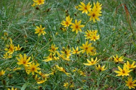
On the subject of flowers, we spotted the following species of sunflower growing alongside the road. Did we find the endangered Schweitzer's Sunflower, known to grow in the Uwharrie Forest, or one of its cousins?


We finished our hike, but instead of backtracking through Troy, we headed north on 109 to NC 49, one of North Carolina's official scenic drives, and soon found more destinations to explore. 

Last year, one of my Sylvan Heights posts caught the attention of the NC Zoo director. He not only invited us to the zoo, he suggested we check out Birkhead Wilderness, located in the northern region of the Uwharrie National Forest. Our zoo trip is a bit overdue thanks to unexpected travel and 100+ temperatures this past summer, but on this trip, we spotted the turnoff for the 5,100 acre Birkhead Wilderness. So many trails, too little time! We put it on the growing lists of places to visit, and continued on, but made a quick turn when we saw the sign for Pisgah Covered Bridge.

A member of our hiking group first told us about this historic structure. Several sources state the Pisgah Covered Bridge is only one of two covered bridges left in North Carolina. Once badly damaged, the bridge was refurbished thanks to efforts initiated by the NC Zoo and Zoo Society. Today, visitors can picnic near the creek or stroll along the hiking trail in what we found to be a picturesque setting.


A must see if you're in the area.

There are several trails to explore in Uwharrie National Forest, Birkhead Wilderness, and nearby Morrow Mountain State Park, and that's not even counting the hike through the NC Zoo. In short, there's plenty to do in the Asheboro area.

And I once called the Piedmont the land between me and the mountains? I stand corrected.

So back we'll go, and soon. Not to explore more of Uwharrie's interior, not yet anyway. We're finally taking that overdue trip to the zoo. But we won't be alone. Accompanying us on the excursion will be a group of siblings who have fast grown dear to our hearts. More soon.

For more information on Uwharrie Forest, activities and trails, go to www.cs.unca.edu/nfsnc/recreation/uwharrie/index.htm

For more information on Morrow Mountain State Park, go to
www.ncparks.gov/Visit/parks/momo/main.php

Tuesday, October 12, 2010

Beaufort, NC: Sanctuary

Visitors to Beaufort NC generally stroll along the sidewalks, shopping for clothes, souvenirs, or confections in one of the stores lining Front Street. Many stop to eat at one of the restaurants overlooking the scenic waters of Taylor's Creek, admiring sailboats resting in placid waters or one of the yachts moored along the shore. But across the creek is a strip of land seen, but ignored until a feral horse appears and begins grazing near the marsh. This is Carrot Island, a "cluster of small islands, salt marshes and spoil banks"(1), also known as the Rachel Carson Estuarine Research Reserve.


Just over three miles long, and one mile wide(2), the reserve is named for the author and scientist who conducted ecological research there in the 1940s(1). It is an estuarine. A place where fresh water meets salt. That mix creates a critical environment for plant and wildlife.

The island system is accessible only by boat, so we parked on Front Street near Island Ferry Adventures in time for the one o'clock departure. Though the trip across the creek took less than five minutes, Captain Farmer gave us a brief tour, providing tidbits on Taylor's Creek and Carrot Island, and then pointed out one of the feral horses grazing in the marsh before dropping us off on the western tip of the island.


Standing on a small stretch of beach within sight of downtown Beaufort isn't the getaway some desire, but within seconds, the scenery caught our attention.


Though we spotted ibises, oyster beds, and the two horses we saw during the ferry ride, the beach ended at the edge of a marsh. Out of walking space, we backtracked through the soft sand and rounded the tip toward the southern end of the island. Minutes later, we encountered hundreds of tiny crabs scurrying from the water to nearby brush.


This crescent strip of sand also ended in a marsh, but a trail led over the dune and into the maritime forest. Following a line of wooden markers, we hiked past evergreens, over burrs that stuck on our socks and shoes, into what we hoped would be the interior of the reserve. We found Indian blankets growing in the sand and teasing views of both the Atlantic and Beaufort.

But no pathway into the interior. Fortunately, the Maritime Museum in Beaufort often hosts a "Horses, Hiking, and History" tour that takes visitors on a three-hour trek through the reserve. For more information, go to www.ncmaritime.org/main/events.htm

During the hike back to the ferry rendezvous point, we were treated to the sight of an osprey flying overhead, and a run in with the fiddler crab's cousin, the ghost crab.


The Rachel Carson unit is one of ten protected estuarines in North Carolina. For information, go to www.nccoastalreserve.net/

For more information on the Rachel Carson Reserve, go to  www.nccoastalreserve.net/About-The-Reserve/National-Reserve-Sites/Rachel-Carson/58.aspx

For more information on Island Ferry Adventures, including tours, destinations, prices and seasonal dates, go to www.islandferryadventures.com/

Our thanks to Captain Farmer and Molly for making our trip even more enjoyable. I look forward to the Shackleford Trip.


1. Natural Traveler: Along North Carolina's Coast (John F Blair) pg 217
2. http://www.nccoastalreserve.net/About-The-Reserve/National-Reserve-Sites/Rachel-Carson/58.aspx

Thursday, October 07, 2010

RE: Carrot Island Post

I'd planned to move ahead with the Carrot Island post this week, sharing information about the crumble of land across the creek from Beaufort, NC, and the Rachel Carson Estuarine Reserve. After viewing photos posted on Carolinafootprints.com, I knew I had to visit the reserve (as opposed to glancing at it from across the water) before writing about it. Check out these photos and you'll understand why.

http://carolinafootprints.com/?p=466

Beautiful.

Saturday, October 02, 2010

Scenes from California

We're back from California, where we met the newest member of our family. We also took our toddling grandson to a couple outdoor destinations to teach him how to enjoy, and appreciate, the great outdoors. Below are a few scenes from our trip. First, from a local recreational area, then from Olde Town and places around San Diego.

Why post photos of California in a blog called Carolina Towns and Trails? As I like to point out to justify these posts, California was originally included in the land grants extended to the Lord Proprietors, those bearing the noble names of Hyde, Albemarle, Craven, Carteret, Ashley Cooper, Berkeley and more: www.ccpl.org/content.asp?catID=6063

This is what they would have seen:


We also checked out Balboa Park in San Diego. Housing trails, gardens, over a dozen museums and restaurants located inside stunning structures built in the Spanish tradition, and the San Diego Zoo, the park is a favorite for visitors and residents living in and around the San Diego area. We stopped by the science museum, and attempted a visit to the Museum of Natural History. Unfortunately, we neglected to check operating times before we went.

Certain I couldn't take photos within the museum, I left my camera in the car. A huge loss. We did, however, snap a couple of photos from the interior of the car.


And nearby...


You can also view photos of Balboa Park on Webshots, and pBase. A must stop if you're in the San Diego area. For more information, go to www.balboapark.org/

California is nice, especially since it's the home of our grandbabies, but I don't blame the Lord Proprietors for sticking close to home. After all, nothing could be finer....well, you know.

Additional Stories

Related Posts with Thumbnails